Abuja geodata
Abuja (FCT) is a capital of a political entity; located in Nigeria in Africa/Lagos (GMT+1) time zone. With population of 590,400 people, there are 14 cities with bigger population in this country. Compared to other cities in Nigeria, 55.6% of cities are located further ↓South; 53.3% of cities are located further ←West and 81% of cities have lower elevation than Abuja. Note1


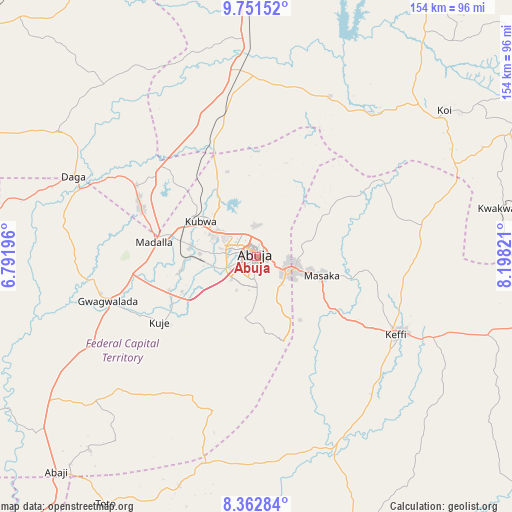
Abuja GPS coordinates[2]
9° 3' 28.26" North, 7° 29' 42.288" East
| Map corner | latitude | longitude |
|---|---|---|
| Upper-left | 9.75152°, | 6.79196° |
| Center: | 9.05785°, | 7.49508° |
| Lower-right: | 8.36284°, | 8.19821° |
| Map W x H: | 154.4×154.4 km | = 95.9×95.9mi |
| max Lat: | 13.7543° ⇑44.4% North |
| Abuja: | 9.05785° |
| min Lat: | ⇓55.6% South 4.31231° |
| min Long | Abuja | max Long |
| 2.73333° | 7.49508° | 14.46552° |
| W 53.3%⇐ | ⇒46.7% E |
Elevation
Elevation of Abuja is 476 m = 1562 ft, and this is 179.5 m = 589 ft above average elevation for this country.
| Max E: |
1599 m = 5246 ft | 19% |
| Abuja | 476 m 1562 ft | |
| Avg. | 296.5 m = 973 ft | |
Min E: |
2 m = 7 ft | 81% |
See also: Abuja elevation on elevation.city.
Geographical zone
Abuja is located in North Torrid zone (between Equator and Tropic of Cancer). Distance of Equator is 1007.1 km =625.8 mi to South.| Distance of | km | miles | from Abuja |
|---|---|---|---|
| North Pole | 8999.9 | 5592.3 | to North |
| Arctic Circle | 6394 | 3973 | to North |
| Tropic Cancer | 1598.8 | 993.4 | to North |
| Equator | 1007.1 | 625.8 | to South |


Nearby cities:
15 places around Abuja: (largest is in red/bold)
• Buga
65.3 km =40.6 mi,  194°
194°
• Bwari
27.7 km =17.2 mi,  333°
333°
• Garaku
73.6 km =45.7 mi,  108°
108°
• Gawu Babangida
60.3 km =37.5 mi,  293°
293°
• Gwagwalada
47.2 km =29.3 mi,  254°
254°
• Kagarko
53.1 km =33 mi,  24°
24°
• Karu
19 km =11.8 mi, 106°
• Keffi
47.8 km =29.7 mi,  119°
119°
• Kuje
35.4 km =22 mi,  235°
235°
• Kwali
55.8 km =34.7 mi, 249°
• Kwoi
71.6 km =44.5 mi,  51°
51°
• Madala
31.4 km =19.5 mi,  279°
279°
• Nasarawa
62.3 km =38.7 mi,  157°
157°
• Sabon Wuse
40 km =24.9 mi,  320°
320°
• Suleja
37.2 km =23.1 mi, 291°
Sources, notices
• [Note1] Compared only with cities in Nigeria existing in our database
• [Src1] Map data: © OpenStreetMap contributors (CC-BY-SA)
• [Src2] Other city data from geonames.org with taken over terms of usage.
• [Src3] Geographical zone / Annual Mean Temperature by Robert A. Rohde @ Wikipedia
