Gwagwalada geodata
Gwagwalada (FCT) is a seat of a second-order administrative division; located in Nigeria in Africa/Lagos (GMT+1) time zone. In our database, there are 451 cities with bigger population. Compared to other cities in Nigeria, 54.6% of cities are located further ↓South; 54.7% of cities are located further →East and 63.4% of cities have higher elevation than Gwagwalada. Note1


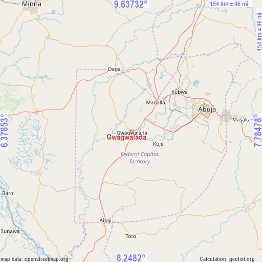
Gwagwalada GPS coordinates[2]
8° 56' 36.312" North, 7° 4' 53.94" East
| Map corner | latitude | longitude |
|---|---|---|
| Upper-left | 9.63732°, | 6.37853° |
| Center: | 8.94342°, | 7.08165° |
| Lower-right: | 8.2482°, | 7.78478° |
| Map W x H: | 154.5×154.5 km | = 96×96mi |
| max Lat: | 13.7543° ⇑45.4% North |
| Gwagwalada: | 8.94342° |
| min Lat: | ⇓54.6% South 4.31231° |
| min Long | Gwagwalada | max Long |
| 2.73333° | 7.08165° | 14.46552° |
| W 45.3%⇐ | ⇒54.7% E |
Elevation
Elevation of Gwagwalada is 186 m = 610 ft, and this is 110.5 m = 363 ft below average elevation for this country.
| Max E: |
1599 m = 5246 ft | 63.4% |
| Avg. | 296.5 m = 973 ft | |
| Gwagwalada | 186 m = 610 ft | |
Min E: |
2 m = 7 ft | 36.6% |
See also: Nigeria elevation on elevation.city.
Geographical zone
Gwagwalada is located in North Torrid zone (between Equator and Tropic of Cancer). Distance of Equator is 994.4 km =617.9 mi to South.| Distance of | km | miles | from Gwagwalada |
|---|---|---|---|
| North Pole | 9012.6 | 5600.2 | to North |
| Arctic Circle | 6406.8 | 3981 | to North |
| Tropic Cancer | 1611.5 | 1001.3 | to North |
| Equator | 994.4 | 617.9 | to South |


Nearby cities:
15 places around Gwagwalada: (largest is in red/bold)
• Abaji
54.4 km =33.8 mi,  196°
196°
• Abuja
47.2 km =29.3 mi,  74°
74°
• Baro
81.5 km =50.6 mi,  243°
243°
• Buga
57.9 km =36 mi,  150°
150°
• Bwari
49.8 km =30.9 mi,  41°
41°
• Gawu Babangida
38.5 km =23.9 mi,  345°
345°
• Karu
64.1 km =39.8 mi,  83°
83°
• Kuje
17.5 km =10.9 mi,  113°
113°
• Kwali
9.6 km =6 mi,  226°
226°
• Lapai
57.2 km =35.5 mi,  281°
281°
• Madala
23 km =14.3 mi, 38°
• Paiko
73.7 km =45.8 mi,  318°
318°
• Sabon Wuse
47.7 km =29.6 mi,  24°
24°
• Suleja
28.5 km =17.7 mi, 22°
• Toto
61.8 km =38.4 mi,  180°
180°
Sources, notices
• [Note1] Compared only with cities in Nigeria existing in our database
• [Src1] Map data: © OpenStreetMap contributors (CC-BY-SA)
• [Src2] Other city data from geonames.org with taken over terms of usage.
• [Src3] Geographical zone / Annual Mean Temperature by Robert A. Rohde @ Wikipedia
