Toto geodata
Toto (Nassarawa) is a seat of a second-order administrative division; located in Nigeria in Africa/Lagos (GMT+1) time zone. In our database, there are 451 cities with bigger population. Compared to other cities in Nigeria, 50.2% of cities are located further ↓South; 54.9% of cities are located further →East and 71.3% of cities have higher elevation than Toto. Note1


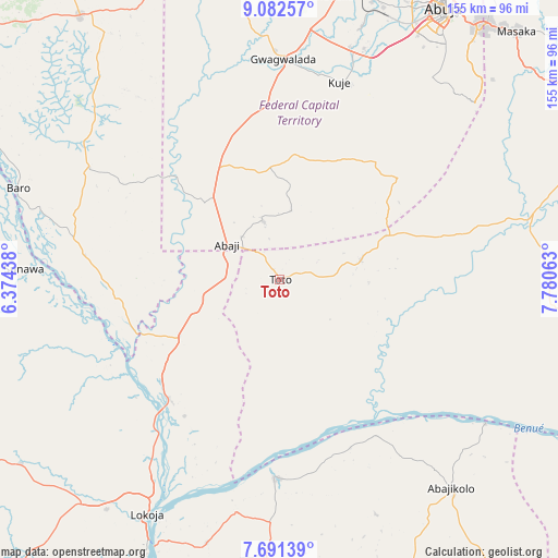
Toto GPS coordinates[2]
8° 23' 15.36" North, 7° 4' 39.036" East
| Map corner | latitude | longitude |
|---|---|---|
| Upper-left | 9.08257°, | 6.37438° |
| Center: | 8.3876°, | 7.07751° |
| Lower-right: | 7.69139°, | 7.78063° |
| Map W x H: | 154.7×154.7 km | = 96.1×96.1mi |
| max Lat: | 13.7543° ⇑49.8% North |
| Toto: | 8.3876° |
| min Lat: | ⇓50.2% South 4.31231° |
| min Long | Toto | max Long |
| 2.73333° | 7.07751° | 14.46552° |
| W 45.1%⇐ | ⇒54.9% E |
Elevation
Elevation of Toto is 140 m = 459 ft, and this is 156.5 m = 513 ft below average elevation for this country.
| Max E: |
1599 m = 5246 ft | 71.3% |
| Avg. | 296.5 m = 973 ft | |
| Toto | 140 m = 459 ft | |
Min E: |
2 m = 7 ft | 28.7% |
See also: Nigeria elevation on elevation.city.
Geographical zone
Toto is located in North Torrid zone (between Equator and Tropic of Cancer). Distance of Equator is 932.6 km =579.5 mi to South.| Distance of | km | miles | from Toto |
|---|---|---|---|
| North Pole | 9074.4 | 5638.6 | to North |
| Arctic Circle | 6468.6 | 4019.4 | to North |
| Tropic Cancer | 1673.3 | 1039.7 | to North |
| Equator | 932.6 | 579.5 | to South |


Nearby cities:
15 places around Toto: (largest is in red/bold)
• Abaji
17.5 km =10.9 mi,  303°
303°
• Abejukolo
74.8 km =46.5 mi,  140°
140°
• Baro
76.8 km =47.7 mi,  289°
289°
• Buga
31.2 km =19.4 mi,  68°
68°
• Bugana
70.5 km =43.8 mi,  127°
127°
• Dekina
77.7 km =48.3 mi,  182°
182°
• Gwagwalada
61.8 km =38.4 mi,  0°
0°
• Icheu
82.9 km =51.5 mi,  203°
203°
• Koton-Karfe
45.1 km =28 mi,  223°
223°
• Kuje
57.1 km =35.5 mi,  16°
16°
• Kwali
55.5 km =34.5 mi,  353°
353°
• Lokoja
75.4 km =46.9 mi,  209°
209°
• Madala
81.1 km =50.4 mi,  10°
10°
• Nasarawa
71.4 km =44.4 mi,  76°
76°
• Oguma
54.6 km =33.9 mi, 181°
Sources, notices
• [Note1] Compared only with cities in Nigeria existing in our database
• [Src1] Map data: © OpenStreetMap contributors (CC-BY-SA)
• [Src2] Other city data from geonames.org with taken over terms of usage.
• [Src3] Geographical zone / Annual Mean Temperature by Robert A. Rohde @ Wikipedia
