Mberubu geodata
Mberubu (Enugu) is a populated place; located in Nigeria in Africa/Lagos (GMT+1) time zone. With population of 8,904 people, there are 359 cities with bigger population in this country. Compared to other cities in Nigeria, 81.7% of cities are located further ↑North; 55.9% of cities are located further ←West and 80.1% of cities have higher elevation than Mberubu. Note1


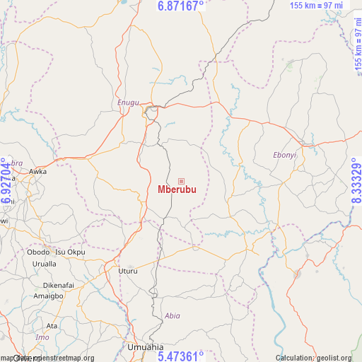
Mberubu GPS coordinates[2]
6° 10' 23.16" North, 7° 37' 48.612" East
| Map corner | latitude | longitude |
|---|---|---|
| Upper-left | 6.87167°, | 6.92704° |
| Center: | 6.1731°, | 7.63017° |
| Lower-right: | 5.47361°, | 8.33329° |
| Map W x H: | 155.4×155.5 km | = 96.6×96.6mi |
| max Lat: | 13.7543° ⇑81.7% North |
| Mberubu: | 6.1731° |
| min Lat: | ⇓18.3% South 4.31231° |
| min Long | Mberubu | max Long |
| 2.73333° | 7.63017° | 14.46552° |
| W 55.9%⇐ | ⇒44.1% E |
Elevation
Elevation of Mberubu is 82 m = 269 ft, and this is 214.5 m = 704 ft below average elevation for this country.
| Max E: |
1599 m = 5246 ft | 80.1% |
| Avg. | 296.5 m = 973 ft | |
| Mberubu | 82 m = 269 ft | |
Min E: |
2 m = 7 ft | 19.9% |
See also: Nigeria elevation on elevation.city.
Geographical zone
Mberubu is located in North Torrid zone (between Equator and Tropic of Cancer). Distance of Equator is 686.4 km =426.5 mi to South.| Distance of | km | miles | from Mberubu |
|---|---|---|---|
| North Pole | 9320.7 | 5791.6 | to North |
| Arctic Circle | 6714.8 | 4172.4 | to North |
| Tropic Cancer | 1919.5 | 1192.7 | to North |
| Equator | 686.4 | 426.5 | to South |


Nearby cities:
15 places around Mberubu: (largest is in red/bold)
• Agbani
17.4 km =10.8 mi,  328°
328°
• Ake-Eze
29 km =18 mi,  169°
169°
• Amagunze
17.7 km =11 mi,  8°
8°
• Awgu
20.2 km =12.6 mi,  236°
236°
• Enugu
33.2 km =20.6 mi, 334°
• Ezillo
35.2 km =21.9 mi,  36°
36°
• Ezzamgbo
44.4 km =27.6 mi,  55°
55°
• Isiaka
35.7 km =22.2 mi,  195°
195°
• Isu
19.1 km =11.9 mi,  97°
97°
• Ndeaboh
16.9 km =10.5 mi, 203°
• Nkwo Nike
39.7 km =24.7 mi,  340°
340°
• Nkwoagu Isuochi
33 km =20.5 mi,  232°
232°
• Obiozara
21.1 km =13.1 mi,  131°
131°
• Oji River
40.8 km =25.4 mi,  282°
282°
• Udi
28.1 km =17.5 mi,  304°
304°
Sources, notices
• [Note1] Compared only with cities in Nigeria existing in our database
• [Src1] Map data: © OpenStreetMap contributors (CC-BY-SA)
• [Src2] Other city data from geonames.org with taken over terms of usage.
• [Src3] Geographical zone / Annual Mean Temperature by Robert A. Rohde @ Wikipedia
