Enugu geodata
Enugu is a seat of a first-order administrative division; located in Nigeria in Africa/Lagos (GMT+1) time zone. With population of 688,862 people, there are 12 cities with bigger population in this country. Compared to other cities in Nigeria, 77.9% of cities are located further ↑North; 53.5% of cities are located further ←West and 62.2% of cities have higher elevation than Enugu. Note1


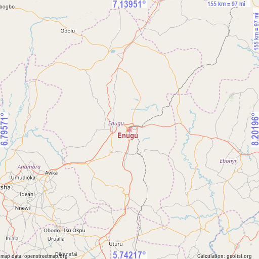
Enugu GPS coordinates[2]
6° 26' 28.752" North, 7° 29' 55.788" East
| Map corner | latitude | longitude |
|---|---|---|
| Upper-left | 7.13951°, | 6.79571° |
| Center: | 6.44132°, | 7.49883° |
| Lower-right: | 5.74217°, | 8.20196° |
| Map W x H: | 155.4×155.4 km | = 96.6×96.6mi |
| max Lat: | 13.7543° ⇑77.9% North |
| Enugu: | 6.44132° |
| min Lat: | ⇓22.1% South 4.31231° |
| min Long | Enugu | max Long |
| 2.73333° | 7.49883° | 14.46552° |
| W 53.5%⇐ | ⇒46.5% E |
Elevation
Elevation of Enugu is 192 m = 630 ft, and this is 104.5 m = 343 ft below average elevation for this country.
| Max E: |
1599 m = 5246 ft | 62.2% |
| Avg. | 296.5 m = 973 ft | |
| Enugu | 192 m = 630 ft | |
Min E: |
2 m = 7 ft | 37.8% |
See also: Enugu elevation on elevation.city.
Geographical zone
Enugu is located in North Torrid zone (between Equator and Tropic of Cancer). Distance of Equator is 716.2 km =445 mi to South.| Distance of | km | miles | from Enugu |
|---|---|---|---|
| North Pole | 9290.9 | 5773.1 | to North |
| Arctic Circle | 6685 | 4153.9 | to North |
| Tropic Cancer | 1889.7 | 1174.2 | to North |
| Equator | 716.2 | 445 | to South |


Nearby cities:
15 places around Enugu: (largest is in red/bold)
• Agbani
15.9 km =9.9 mi,  159°
159°
• Aguobu-Owa
26.2 km =16.3 mi,  252°
252°
• Aku
35.8 km =22.2 mi,  326°
326°
• Amagunze
21 km =13 mi,  125°
125°
• Awgu
41 km =25.5 mi,  183°
183°
• Eha Amufu
37.6 km =23.4 mi,  49°
49°
• Ezillo
35.3 km =21.9 mi,  92°
92°
• Ikem
44.6 km =27.7 mi,  32°
32°
• Mberubu
33.2 km =20.6 mi,  154°
154°
• Nkwo Nike
7.6 km =4.7 mi,  9°
9°
• Ogbede
29.2 km =18.1 mi, 331°
• Oji River
32.6 km =20.3 mi,  230°
230°
• Opi
38.6 km =24 mi,  349°
349°
• Udi
16.4 km =10.2 mi,  211°
211°
• Umulona
45 km =28 mi,  279°
279°
Sources, notices
• [Note1] Compared only with cities in Nigeria existing in our database
• [Src1] Map data: © OpenStreetMap contributors (CC-BY-SA)
• [Src2] Other city data from geonames.org with taken over terms of usage.
• [Src3] Geographical zone / Annual Mean Temperature by Robert A. Rohde @ Wikipedia
