Ndeaboh geodata
Ndeaboh (Enugu) is a seat of a second-order administrative division; located in Nigeria in Africa/Lagos (GMT+1) time zone. In our database, there are 451 cities with bigger population. Compared to other cities in Nigeria, 83.3% of cities are located further ↑North; 55% of cities are located further ←West and 79.7% of cities have higher elevation than Ndeaboh. Note1


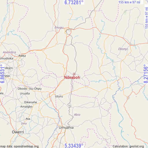
Ndeaboh GPS coordinates[2]
6° 2' 2.58" North, 7° 34' 6.348" East
| Map corner | latitude | longitude |
|---|---|---|
| Upper-left | 6.73281°, | 6.86531° |
| Center: | 6.03405°, | 7.56843° |
| Lower-right: | 5.33439°, | 8.27156° |
| Map W x H: | 155.5×155.5 km | = 96.6×96.6mi |
| max Lat: | 13.7543° ⇑83.3% North |
| Ndeaboh: | 6.03405° |
| min Lat: | ⇓16.7% South 4.31231° |
| min Long | Ndeaboh | max Long |
| 2.73333° | 7.56843° | 14.46552° |
| W 55%⇐ | ⇒45% E |
Elevation
Elevation of Ndeaboh is 83 m = 272 ft, and this is 213.5 m = 700 ft below average elevation for this country.
| Max E: |
1599 m = 5246 ft | 79.7% |
| Avg. | 296.5 m = 973 ft | |
| Ndeaboh | 83 m = 272 ft | |
Min E: |
2 m = 7 ft | 20.3% |
See also: Nigeria elevation on elevation.city.
Geographical zone
Ndeaboh is located in North Torrid zone (between Equator and Tropic of Cancer). Distance of Equator is 670.9 km =416.9 mi to South.| Distance of | km | miles | from Ndeaboh |
|---|---|---|---|
| North Pole | 9336.1 | 5801.2 | to North |
| Arctic Circle | 6730.3 | 4182 | to North |
| Tropic Cancer | 1935 | 1202.4 | to North |
| Equator | 670.9 | 416.9 | to South |


Nearby cities:
15 places around Ndeaboh: (largest is in red/bold)
• Agbani
30.4 km =18.9 mi,  355°
355°
• Ajalli
39.8 km =24.7 mi,  271°
271°
• Ake-Eze
17.7 km =11 mi,  137°
137°
• Amagunze
34.3 km =21.3 mi,  15°
15°
• Amaigbo
40.4 km =25.1 mi,  132°
132°
• Awgu
10.9 km =6.8 mi,  293°
293°
• Isiaka
19.2 km =11.9 mi,  187°
187°
• Isu
28.8 km =17.9 mi,  63°
63°
• Mbalano
34.1 km =21.2 mi, 192°
• Mberubu
16.9 km =10.5 mi, 23°
• Nkwoagu Isuochi
19.8 km =12.3 mi,  256°
256°
• Obiozara
22.6 km =14 mi,  86°
86°
• Okigwe
33.2 km =20.6 mi,  226°
226°
• Udi
35.3 km =21.9 mi,  332°
332°
• Umunze
37.4 km =23.2 mi, 258°
Sources, notices
• [Note1] Compared only with cities in Nigeria existing in our database
• [Src1] Map data: © OpenStreetMap contributors (CC-BY-SA)
• [Src2] Other city data from geonames.org with taken over terms of usage.
• [Src3] Geographical zone / Annual Mean Temperature by Robert A. Rohde @ Wikipedia
