Udi geodata
Udi (Enugu) is a seat of a second-order administrative division; located in Nigeria in Africa/Lagos (GMT+1) time zone. With population of 14,998 people, there are 243 cities with bigger population in this country. Compared to other cities in Nigeria, 79.9% of cities are located further ↑North; 52.2% of cities are located further ←West and 75.8% of cities have lower elevation than Udi. Note1


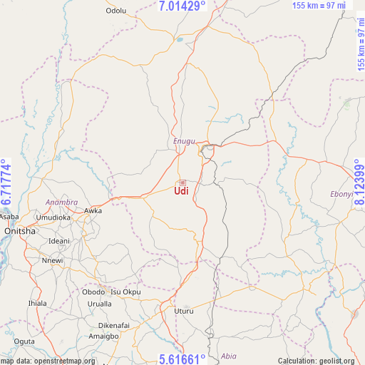
Udi GPS coordinates[2]
6° 18' 57.312" North, 7° 25' 15.096" East
| Map corner | latitude | longitude |
|---|---|---|
| Upper-left | 7.01429°, | 6.71774° |
| Center: | 6.31592°, | 7.42086° |
| Lower-right: | 5.61661°, | 8.12399° |
| Map W x H: | 155.4×155.4 km | = 96.6×96.6mi |
| max Lat: | 13.7543° ⇑79.9% North |
| Udi: | 6.31592° |
| min Lat: | ⇓20.1% South 4.31231° |
| min Long | Udi | max Long |
| 2.73333° | 7.42086° | 14.46552° |
| W 52.2%⇐ | ⇒47.8% E |
Elevation
Elevation of Udi is 437 m = 1434 ft, and this is 140.5 m = 461 ft above average elevation for this country.
| Max E: |
1599 m = 5246 ft | 24.2% |
| Udi | 437 m 1434 ft | |
| Avg. | 296.5 m = 973 ft | |
Min E: |
2 m = 7 ft | 75.8% |
See also: Nigeria elevation on elevation.city.
Geographical zone
Udi is located in North Torrid zone (between Equator and Tropic of Cancer). Distance of Equator is 702.3 km =436.4 mi to South.| Distance of | km | miles | from Udi |
|---|---|---|---|
| North Pole | 9304.8 | 5781.7 | to North |
| Arctic Circle | 6698.9 | 4162.5 | to North |
| Tropic Cancer | 1903.7 | 1182.9 | to North |
| Equator | 702.3 | 436.4 | to South |


Nearby cities:
15 places around Udi: (largest is in red/bold)
• Agbani
14.2 km =8.8 mi,  94°
94°
• Aguobu-Owa
17.6 km =10.9 mi,  290°
290°
• Ajalli
38.2 km =23.7 mi,  217°
217°
• Amagunze
25.6 km =15.9 mi, 86°
• Awgu
27.7 km =17.2 mi,  166°
166°
• Awka
40.2 km =25 mi,  253°
253°
• Enugu
16.4 km =10.2 mi,  31°
31°
• Mberubu
28.1 km =17.5 mi,  124°
124°
• Ndeaboh
35.3 km =21.9 mi,  152°
152°
• Nkwo Nike
23.6 km =14.7 mi,  24°
24°
• Nkwoagu Isuochi
36.2 km =22.5 mi,  184°
184°
• Ogbede
40 km =24.9 mi,  352°
352°
• Oji River
17.9 km =11.1 mi, 248°
• Umulona
41.6 km =25.8 mi,  300°
300°
• Umunze
43.8 km =27.2 mi,  207°
207°
Sources, notices
• [Note1] Compared only with cities in Nigeria existing in our database
• [Src1] Map data: © OpenStreetMap contributors (CC-BY-SA)
• [Src2] Other city data from geonames.org with taken over terms of usage.
• [Src3] Geographical zone / Annual Mean Temperature by Robert A. Rohde @ Wikipedia
