Lafia geodata
Lafia (Nassarawa) is a seat of a first-order administrative division; located in Nigeria in Africa/Lagos (GMT+1) time zone. With population of 127,236 people, there are 67 cities with bigger population in this country. Compared to other cities in Nigeria, 50.8% of cities are located further ↓South; 71.9% of cities are located further ←West and 65% of cities have higher elevation than Lafia. Note1


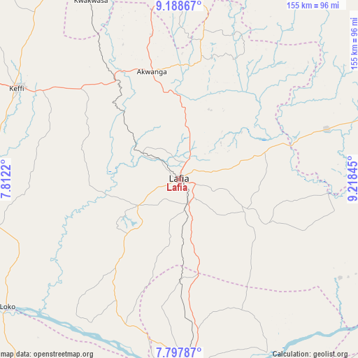
Lafia GPS coordinates[2]
8° 29' 38.04" North, 8° 30' 55.152" East
| Map corner | latitude | longitude |
|---|---|---|
| Upper-left | 9.18867°, | 7.8122° |
| Center: | 8.4939°, | 8.51532° |
| Lower-right: | 7.79787°, | 9.21845° |
| Map W x H: | 154.6×154.6 km | = 96.1×96.1mi |
| max Lat: | 13.7543° ⇑49.2% North |
| Lafia: | 8.4939° |
| min Lat: | ⇓50.8% South 4.31231° |
| min Long | Lafia | max Long |
| 2.73333° | 8.51532° | 14.46552° |
| W 71.9%⇐ | ⇒28.1% E |
Elevation
Elevation of Lafia is 179 m = 587 ft, and this is 117.5 m = 385 ft below average elevation for this country.
| Max E: |
1599 m = 5246 ft | 65% |
| Avg. | 296.5 m = 973 ft | |
| Lafia | 179 m = 587 ft | |
Min E: |
2 m = 7 ft | 35% |
See also: Lafia elevation on elevation.city.
Geographical zone
Lafia is located in North Torrid zone (between Equator and Tropic of Cancer). Distance of Equator is 944.4 km =586.8 mi to South.| Distance of | km | miles | from Lafia |
|---|---|---|---|
| North Pole | 9062.6 | 5631.2 | to North |
| Arctic Circle | 6456.7 | 4012 | to North |
| Tropic Cancer | 1661.5 | 1032.4 | to North |
| Equator | 944.4 | 586.8 | to South |


Nearby cities:
15 places around Lafia: (largest is in red/bold)
• Akwanga
47.9 km =29.8 mi,  345°
345°
• Awe
81.2 km =50.5 mi,  122°
122°
• Baap
94.1 km =58.5 mi,  57°
57°
• Doma
20.9 km =13 mi,  237°
237°
• Garaku
57.7 km =35.9 mi,  312°
312°
• Gbajimba
83.9 km =52.1 mi,  153°
153°
• Gwantu
82 km =51 mi,  355°
355°
• Keana
49.4 km =30.7 mi,  141°
141°
• Keffi
80.7 km =50.1 mi,  299°
299°
• Makurdi
84.5 km =52.5 mi,  179°
179°
• Nasarawa
88.9 km =55.2 mi,  273°
273°
• Nasarawa Egon
24.4 km =15.2 mi,  6°
6°
• Obagaji
94.5 km =58.7 mi,  224°
224°
• Obi
31.6 km =19.6 mi, 115°
• Wamba
50.7 km =31.5 mi, 10°
Sources, notices
• [Note1] Compared only with cities in Nigeria existing in our database
• [Src1] Map data: © OpenStreetMap contributors (CC-BY-SA)
• [Src2] Other city data from geonames.org with taken over terms of usage.
• [Src3] Geographical zone / Annual Mean Temperature by Robert A. Rohde @ Wikipedia
