Akwanga geodata
Akwanga (Nassarawa) is a seat of a second-order administrative division; located in Nigeria in Africa/Lagos (GMT+1) time zone. With population of 15,985 people, there are 228 cities with bigger population in this country. Compared to other cities in Nigeria, 54.1% of cities are located further ↓South; 70.4% of cities are located further ←West and 78.2% of cities have lower elevation than Akwanga. Note1


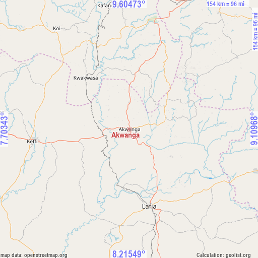
Akwanga GPS coordinates[2]
8° 54' 38.772" North, 8° 24' 23.58" East
| Map corner | latitude | longitude |
|---|---|---|
| Upper-left | 9.60473°, | 7.70343° |
| Center: | 8.91077°, | 8.40655° |
| Lower-right: | 8.21549°, | 9.10968° |
| Map W x H: | 154.5×154.5 km | = 96×96mi |
| max Lat: | 13.7543° ⇑45.9% North |
| Akwanga: | 8.91077° |
| min Lat: | ⇓54.1% South 4.31231° |
| min Long | Akwanga | max Long |
| 2.73333° | 8.40655° | 14.46552° |
| W 70.4%⇐ | ⇒29.6% E |
Elevation
Elevation of Akwanga is 454 m = 1490 ft, and this is 157.5 m = 517 ft above average elevation for this country.
| Max E: |
1599 m = 5246 ft | 21.8% |
| Akwanga | 454 m 1490 ft | |
| Avg. | 296.5 m = 973 ft | |
Min E: |
2 m = 7 ft | 78.2% |
See also: Nigeria elevation on elevation.city.
Geographical zone
Akwanga is located in North Torrid zone (between Equator and Tropic of Cancer). Distance of Equator is 990.8 km =615.7 mi to South.| Distance of | km | miles | from Akwanga |
|---|---|---|---|
| North Pole | 9016.3 | 5602.5 | to North |
| Arctic Circle | 6410.4 | 3983.2 | to North |
| Tropic Cancer | 1615.1 | 1003.6 | to North |
| Equator | 990.8 | 615.7 | to South |


Nearby cities:
15 places around Akwanga: (largest is in red/bold)
• Bokkos
77.7 km =48.3 mi,  56°
56°
• Doma
57.8 km =35.9 mi,  185°
185°
• Garaku
31.2 km =19.4 mi,  256°
256°
• Gwantu
35.8 km =22.2 mi,  9°
9°
• Kafanchan
75.6 km =47 mi,  350°
350°
• Kagoro
77.5 km =48.2 mi,  358°
358°
• Karu
82.6 km =51.3 mi,  277°
277°
• Kaura
84.4 km =52.4 mi,  3°
3°
• Keffi
59 km =36.7 mi, 263°
• Kwoi
75 km =46.6 mi,  324°
324°
• Lafia
47.9 km =29.8 mi,  165°
165°
• Nasarawa
87.2 km =54.2 mi,  241°
241°
• Nasarawa Egon
26.5 km =16.5 mi,  146°
146°
• Obi
72.5 km =45 mi, 146°
• Wamba
21.9 km =13.6 mi,  81°
81°
Sources, notices
• [Note1] Compared only with cities in Nigeria existing in our database
• [Src1] Map data: © OpenStreetMap contributors (CC-BY-SA)
• [Src2] Other city data from geonames.org with taken over terms of usage.
• [Src3] Geographical zone / Annual Mean Temperature by Robert A. Rohde @ Wikipedia
