Gwantu geodata
Gwantu (Kaduna) is a seat of a second-order administrative division; located in Nigeria in Africa/Lagos (GMT+1) time zone. In our database, there are 451 cities with bigger population. Compared to other cities in Nigeria, 57.1% of cities are located further ↓South; 70.9% of cities are located further ←West and 89.5% of cities have lower elevation than Gwantu. Note1


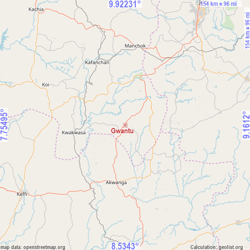
Gwantu GPS coordinates[2]
9° 13' 44.364" North, 8° 27' 29.052" East
| Map corner | latitude | longitude |
|---|---|---|
| Upper-left | 9.92231°, | 7.75495° |
| Center: | 9.22899°, | 8.45807° |
| Lower-right: | 8.5343°, | 9.1612° |
| Map W x H: | 154.3×154.3 km | = 95.9×95.9mi |
| max Lat: | 13.7543° ⇑42.9% North |
| Gwantu: | 9.22899° |
| min Lat: | ⇓57.1% South 4.31231° |
| min Long | Gwantu | max Long |
| 2.73333° | 8.45807° | 14.46552° |
| W 70.9%⇐ | ⇒29.1% E |
Elevation
Elevation of Gwantu is 549 m = 1801 ft, and this is 252.5 m = 828 ft above average elevation for this country.
| Max E: |
1599 m = 5246 ft | 10.5% |
| Gwantu | 549 m 1801 ft | |
| Avg. | 296.5 m = 973 ft | |
Min E: |
2 m = 7 ft | 89.5% |
See also: Nigeria elevation on elevation.city.
Geographical zone
Gwantu is located in North Torrid zone (between Equator and Tropic of Cancer). Distance of Equator is 1026.2 km =637.7 mi to South.| Distance of | km | miles | from Gwantu |
|---|---|---|---|
| North Pole | 8980.9 | 5580.5 | to North |
| Arctic Circle | 6375 | 3961.2 | to North |
| Tropic Cancer | 1579.8 | 981.6 | to North |
| Equator | 1026.2 | 637.7 | to South |


Nearby cities:
15 places around Gwantu: (largest is in red/bold)
• Akwanga
35.8 km =22.2 mi,  189°
189°
• Barkin Ladi
58.8 km =36.5 mi,  54°
54°
• Bokkos
59.4 km =36.9 mi,  82°
82°
• Bukuru
77 km =47.8 mi,  35°
35°
• Garaku
55.7 km =34.6 mi,  220°
220°
• Kafanchan
43.2 km =26.8 mi,  335°
335°
• Kagoro
42.8 km =26.6 mi,  350°
350°
• Kaura
48.8 km =30.3 mi,  0°
0°
• Keffi
77 km =47.8 mi,  236°
236°
• Kwoi
55.6 km =34.5 mi,  297°
297°
• Nasarawa Egon
58.2 km =36.2 mi,  171°
171°
• Riyom
56 km =34.8 mi, 35°
• Vom
66.5 km =41.3 mi,  33°
33°
• Wamba
35.7 km =22.2 mi,  153°
153°
• Zonkwa
64.4 km =40 mi, 343°
Sources, notices
• [Note1] Compared only with cities in Nigeria existing in our database
• [Src1] Map data: © OpenStreetMap contributors (CC-BY-SA)
• [Src2] Other city data from geonames.org with taken over terms of usage.
• [Src3] Geographical zone / Annual Mean Temperature by Robert A. Rohde @ Wikipedia
