Kunchi geodata
Kunchi (Kano) is a seat of a second-order administrative division; located in Nigeria in Africa/Lagos (GMT+1) time zone. In our database, there are 451 cities with bigger population. Compared to other cities in Nigeria, 90.9% of cities are located further ↓South; 68.3% of cities are located further ←West and 81.5% of cities have lower elevation than Kunchi. Note1


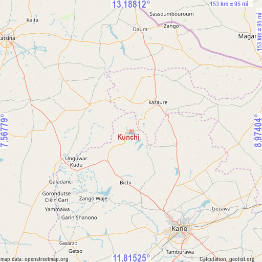
Kunchi GPS coordinates[2]
12° 30' 9.36" North, 8° 16' 15.312" East
| Map corner | latitude | longitude |
|---|---|---|
| Upper-left | 13.18812°, | 7.56779° |
| Center: | 12.5026°, | 8.27092° |
| Lower-right: | 11.81525°, | 8.97404° |
| Map W x H: | 152.6×152.7 km | = 94.8×94.9mi |
| max Lat: | 13.7543° ⇑9.1% North |
| Kunchi: | 12.5026° |
| min Lat: | ⇓90.9% South 4.31231° |
| min Long | Kunchi | max Long |
| 2.73333° | 8.27092° | 14.46552° |
| W 68.3%⇐ | ⇒31.7% E |
Elevation
Elevation of Kunchi is 480 m = 1575 ft, and this is 183.5 m = 602 ft above average elevation for this country.
| Max E: |
1599 m = 5246 ft | 18.5% |
| Kunchi | 480 m 1575 ft | |
| Avg. | 296.5 m = 973 ft | |
Min E: |
2 m = 7 ft | 81.5% |
See also: Nigeria elevation on elevation.city.
Geographical zone
Kunchi is located in North Torrid zone (between Equator and Tropic of Cancer). Distance of this Northern Tropic circle is 1215.8 km =755.5 mi to North.| Distance of | km | miles | from Kunchi |
|---|---|---|---|
| North Pole | 8616.9 | 5354.3 | to North |
| Arctic Circle | 6011 | 3735.1 | to North |
| Tropic Cancer | 1215.8 | 755.5 | to North |
| Equator | 1390.2 | 863.8 | to South |


Nearby cities:
15 places around Kunchi: (largest is in red/bold)
• Bagwai
41.1 km =25.5 mi,  200°
200°
• Bichi
30.1 km =18.7 mi,  186°
186°
• Dambatta
27.6 km =17.1 mi,  105°
105°
• Dawakin Tofa
44.7 km =27.8 mi,  171°
171°
• Dutsi
38.9 km =24.2 mi,  338°
338°
• Gwiwa
31.9 km =19.8 mi,  13°
13°
• Ingawa
28.4 km =17.6 mi,  302°
302°
• Kankia
48.9 km =30.4 mi,  275°
275°
• Karkarna
39.2 km =24.4 mi,  41°
41°
• Kazaure
22.3 km =13.9 mi, 43°
• Koguna
24.3 km =15.1 mi,  123°
123°
• Kusada
32 km =19.9 mi,  262°
262°
• Roni
17.4 km =10.8 mi,  357°
357°
• Tofa
49.4 km =30.7 mi,  179°
179°
• Tsanyawa
38.5 km =23.9 mi,  233°
233°
Sources, notices
• [Note1] Compared only with cities in Nigeria existing in our database
• [Src1] Map data: © OpenStreetMap contributors (CC-BY-SA)
• [Src2] Other city data from geonames.org with taken over terms of usage.
• [Src3] Geographical zone / Annual Mean Temperature by Robert A. Rohde @ Wikipedia
