Kazaure geodata
Kazaure (Jigawa) is a seat of a second-order administrative division; located in Nigeria in Africa/Lagos (GMT+1) time zone. With population of 13,169 people, there are 271 cities with bigger population in this country. Compared to other cities in Nigeria, 92.6% of cities are located further ↓South; 70.5% of cities are located further ←West and 77% of cities have lower elevation than Kazaure. Note1


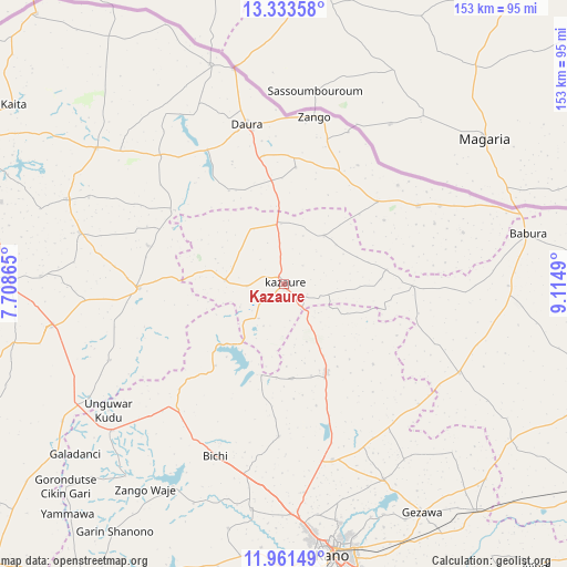
Kazaure GPS coordinates[2]
12° 38' 54.456" North, 8° 24' 42.408" East
| Map corner | latitude | longitude |
|---|---|---|
| Upper-left | 13.33358°, | 7.70865° |
| Center: | 12.64846°, | 8.41178° |
| Lower-right: | 11.96149°, | 9.1149° |
| Map W x H: | 152.6×152.6 km | = 94.8×94.8mi |
| max Lat: | 13.7543° ⇑7.4% North |
| Kazaure: | 12.64846° |
| min Lat: | ⇓92.6% South 4.31231° |
| min Long | Kazaure | max Long |
| 2.73333° | 8.41178° | 14.46552° |
| W 70.5%⇐ | ⇒29.5% E |
Elevation
Elevation of Kazaure is 444 m = 1457 ft, and this is 147.5 m = 484 ft above average elevation for this country.
| Max E: |
1599 m = 5246 ft | 23% |
| Kazaure | 444 m 1457 ft | |
| Avg. | 296.5 m = 973 ft | |
Min E: |
2 m = 7 ft | 77% |
See also: Nigeria elevation on elevation.city.
Geographical zone
Kazaure is located in North Torrid zone (between Equator and Tropic of Cancer). Distance of this Northern Tropic circle is 1199.5 km =745.3 mi to North.| Distance of | km | miles | from Kazaure |
|---|---|---|---|
| North Pole | 8600.7 | 5344.2 | to North |
| Arctic Circle | 5994.8 | 3725 | to North |
| Tropic Cancer | 1199.5 | 745.3 | to North |
| Equator | 1406.4 | 873.9 | to South |


Nearby cities:
15 places around Kazaure: (largest is in red/bold)
• Baure
41.8 km =26 mi,  59°
59°
• Bichi
49.7 km =30.9 mi,  201°
201°
• Dambatta
26.3 km =16.3 mi,  154°
154°
• Daura
43.8 km =27.2 mi,  347°
347°
• Dutsi
35.7 km =22.2 mi,  304°
304°
• Gwiwa
16.9 km =10.5 mi,  331°
331°
• Ingawa
39.1 km =24.3 mi,  268°
268°
• Karkarna
16.9 km =10.5 mi,  39°
39°
• Koguna
30.1 km =18.7 mi,  170°
170°
• Kunchi
22.3 km =13.9 mi,  223°
223°
• Kusada
51.2 km =31.8 mi,  246°
246°
• Minjibir
58.8 km =36.5 mi, 152°
• Roni
16 km =9.9 mi, 274°
• Sandamu
35.3 km =21.9 mi, 350°
• Zango
45.7 km =28.4 mi,  10°
10°
Sources, notices
• [Note1] Compared only with cities in Nigeria existing in our database
• [Src1] Map data: © OpenStreetMap contributors (CC-BY-SA)
• [Src2] Other city data from geonames.org with taken over terms of usage.
• [Src3] Geographical zone / Annual Mean Temperature by Robert A. Rohde @ Wikipedia
