Karkarna geodata
Karkarna (Jigawa) is a seat of a second-order administrative division; located in Nigeria in Africa/Lagos (GMT+1) time zone. In our database, there are 451 cities with bigger population. Compared to other cities in Nigeria, 94.3% of cities are located further ↓South; 71.7% of cities are located further ←West and 76.4% of cities have lower elevation than Karkarna. Note1


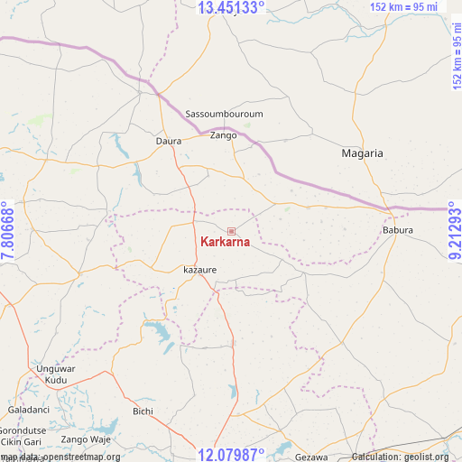
Karkarna GPS coordinates[2]
12° 45' 59.508" North, 8° 30' 35.316" East
| Map corner | latitude | longitude |
|---|---|---|
| Upper-left | 13.45133°, | 7.80668° |
| Center: | 12.76653°, | 8.50981° |
| Lower-right: | 12.07987°, | 9.21293° |
| Map W x H: | 152.5×152.5 km | = 94.8×94.8mi |
| max Lat: | 13.7543° ⇑5.7% North |
| Karkarna: | 12.76653° |
| min Lat: | ⇓94.3% South 4.31231° |
| min Long | Karkarna | max Long |
| 2.73333° | 8.50981° | 14.46552° |
| W 71.7%⇐ | ⇒28.3% E |
Elevation
Elevation of Karkarna is 440 m = 1444 ft, and this is 143.5 m = 471 ft above average elevation for this country.
| Max E: |
1599 m = 5246 ft | 23.6% |
| Karkarna | 440 m 1444 ft | |
| Avg. | 296.5 m = 973 ft | |
Min E: |
2 m = 7 ft | 76.4% |
See also: Nigeria elevation on elevation.city.
Geographical zone
Karkarna is located in North Torrid zone (between Equator and Tropic of Cancer). Distance of this Northern Tropic circle is 1186.4 km =737.2 mi to North.| Distance of | km | miles | from Karkarna |
|---|---|---|---|
| North Pole | 8587.6 | 5336.1 | to North |
| Arctic Circle | 5981.7 | 3716.9 | to North |
| Tropic Cancer | 1186.4 | 737.2 | to North |
| Equator | 1419.5 | 882 | to South |


Nearby cities:
15 places around Karkarna: (largest is in red/bold)
• Babura
54.8 km =34.1 mi,  89°
89°
• Baure
26.7 km =16.6 mi,  72°
72°
• Dambatta
36.9 km =22.9 mi,  179°
179°
• Daura
35.9 km =22.3 mi,  325°
325°
• Dutsi
40.7 km =25.3 mi,  279°
279°
• Gwiwa
18.8 km =11.7 mi, 275°
• Ingawa
51.6 km =32.1 mi,  254°
254°
• Kazaure
16.9 km =10.5 mi,  219°
219°
• Koguna
43.2 km =26.8 mi,  187°
187°
• Kunchi
39.2 km =24.4 mi, 221°
• Mai’Adua
55 km =34.2 mi, 326°
• Mashi
65.5 km =40.7 mi,  291°
291°
• Roni
29.1 km =18.1 mi, 245°
• Sandamu
27.1 km =16.8 mi,  323°
323°
• Zango
32 km =19.9 mi,  355°
355°
Sources, notices
• [Note1] Compared only with cities in Nigeria existing in our database
• [Src1] Map data: © OpenStreetMap contributors (CC-BY-SA)
• [Src2] Other city data from geonames.org with taken over terms of usage.
• [Src3] Geographical zone / Annual Mean Temperature by Robert A. Rohde @ Wikipedia
