Ingawa geodata
Ingawa (Katsina) is a seat of a second-order administrative division; located in Nigeria in Africa/Lagos (GMT+1) time zone. In our database, there are 451 cities with bigger population. Compared to other cities in Nigeria, 92.4% of cities are located further ↓South; 64.6% of cities are located further ←West and 86.3% of cities have lower elevation than Ingawa. Note1


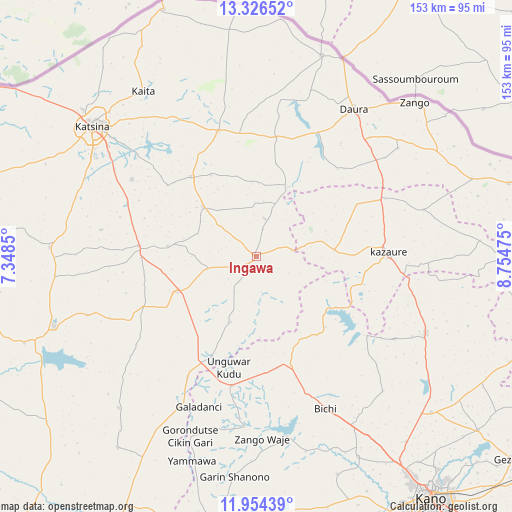
Ingawa GPS coordinates[2]
12° 38' 28.968" North, 8° 3' 5.832" East
| Map corner | latitude | longitude |
|---|---|---|
| Upper-left | 13.32652°, | 7.3485° |
| Center: | 12.64138°, | 8.05162° |
| Lower-right: | 11.95439°, | 8.75475° |
| Map W x H: | 152.6×152.6 km | = 94.8×94.8mi |
| max Lat: | 13.7543° ⇑7.6% North |
| Ingawa: | 12.64138° |
| min Lat: | ⇓92.4% South 4.31231° |
| min Long | Ingawa | max Long |
| 2.73333° | 8.05162° | 14.46552° |
| W 64.6%⇐ | ⇒35.4% E |
Elevation
Elevation of Ingawa is 516 m = 1693 ft, and this is 219.5 m = 720 ft above average elevation for this country.
| Max E: |
1599 m = 5246 ft | 13.7% |
| Ingawa | 516 m 1693 ft | |
| Avg. | 296.5 m = 973 ft | |
Min E: |
2 m = 7 ft | 86.3% |
See also: Nigeria elevation on elevation.city.
Geographical zone
Ingawa is located in North Torrid zone (between Equator and Tropic of Cancer). Distance of this Northern Tropic circle is 1200.3 km =745.8 mi to North.| Distance of | km | miles | from Ingawa |
|---|---|---|---|
| North Pole | 8601.5 | 5344.7 | to North |
| Arctic Circle | 5995.6 | 3725.5 | to North |
| Tropic Cancer | 1200.3 | 745.8 | to North |
| Equator | 1405.6 | 873.4 | to South |


Nearby cities:
15 places around Ingawa: (largest is in red/bold)
• Bichi
49.7 km =30.9 mi,  155°
155°
• Bindawa
26.5 km =16.5 mi,  276°
276°
• Charanchi
35.1 km =21.8 mi, 275°
• Dutsi
22.9 km =14.2 mi,  24°
24°
• Gwiwa
34.7 km =21.6 mi,  63°
63°
• Kankia
27 km =16.8 mi,  246°
246°
• Kazaure
39.1 km =24.3 mi,  88°
88°
• Kunchi
28.4 km =17.6 mi,  122°
122°
• Kusada
21.1 km =13.1 mi,  202°
202°
• Mani
30.4 km =18.9 mi,  321°
321°
• Mashi
39.4 km =24.5 mi,  343°
343°
• Rimi
43.8 km =27.2 mi,  302°
302°
• Roni
23.2 km =14.4 mi, 85°
• Sandamu
48.9 km =30.4 mi,  43°
43°
• Tsanyawa
39.1 km =24.3 mi,  190°
190°
Sources, notices
• [Note1] Compared only with cities in Nigeria existing in our database
• [Src1] Map data: © OpenStreetMap contributors (CC-BY-SA)
• [Src2] Other city data from geonames.org with taken over terms of usage.
• [Src3] Geographical zone / Annual Mean Temperature by Robert A. Rohde @ Wikipedia
