Dutsi geodata
Dutsi (Katsina) is a seat of a second-order administrative division; located in Nigeria in Africa/Lagos (GMT+1) time zone. In our database, there are 451 cities with bigger population. Compared to other cities in Nigeria, 94.9% of cities are located further ↓South; 66.1% of cities are located further ←West and 83% of cities have lower elevation than Dutsi. Note1


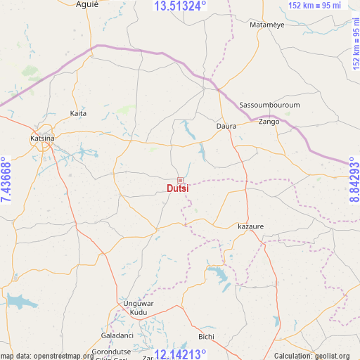
Dutsi GPS coordinates[2]
12° 49' 43.032" North, 8° 8' 23.28" East
| Map corner | latitude | longitude |
|---|---|---|
| Upper-left | 13.51324°, | 7.43668° |
| Center: | 12.82862°, | 8.1398° |
| Lower-right: | 12.14213°, | 8.84293° |
| Map W x H: | 152.5×152.5 km | = 94.8×94.8mi |
| max Lat: | 13.7543° ⇑5.1% North |
| Dutsi: | 12.82862° |
| min Lat: | ⇓94.9% South 4.31231° |
| min Long | Dutsi | max Long |
| 2.73333° | 8.1398° | 14.46552° |
| W 66.1%⇐ | ⇒33.9% E |
Elevation
Elevation of Dutsi is 489 m = 1604 ft, and this is 192.5 m = 632 ft above average elevation for this country.
| Max E: |
1599 m = 5246 ft | 17% |
| Dutsi | 489 m 1604 ft | |
| Avg. | 296.5 m = 973 ft | |
Min E: |
2 m = 7 ft | 83% |
See also: Nigeria elevation on elevation.city.
Geographical zone
Dutsi is located in North Torrid zone (between Equator and Tropic of Cancer). Distance of this Northern Tropic circle is 1179.5 km =732.9 mi to North.| Distance of | km | miles | from Dutsi |
|---|---|---|---|
| North Pole | 8580.7 | 5331.8 | to North |
| Arctic Circle | 5974.8 | 3712.6 | to North |
| Tropic Cancer | 1179.5 | 732.9 | to North |
| Equator | 1426.4 | 886.3 | to South |


Nearby cities:
15 places around Dutsi: (largest is in red/bold)
• Bindawa
40 km =24.9 mi,  243°
243°
• Daura
30.2 km =18.8 mi,  41°
41°
• Gwiwa
22 km =13.7 mi,  103°
103°
• Ingawa
22.9 km =14.2 mi,  204°
204°
• Kankia
46.6 km =29 mi,  227°
227°
• Karkarna
40.7 km =25.3 mi, 99°
• Kazaure
35.7 km =22.2 mi,  124°
124°
• Kunchi
38.9 km =24.2 mi,  158°
158°
• Kusada
44 km =27.3 mi, 203°
• Mai’Adua
40.3 km =25 mi,  14°
14°
• Mani
28.8 km =17.9 mi,  275°
275°
• Mashi
26.9 km =16.7 mi,  308°
308°
• Roni
23.3 km =14.5 mi,  144°
144°
• Sandamu
28.1 km =17.5 mi,  58°
58°
• Zango
45 km =28 mi, 56°
Sources, notices
• [Note1] Compared only with cities in Nigeria existing in our database
• [Src1] Map data: © OpenStreetMap contributors (CC-BY-SA)
• [Src2] Other city data from geonames.org with taken over terms of usage.
• [Src3] Geographical zone / Annual Mean Temperature by Robert A. Rohde @ Wikipedia
