Owo geodata
Owo (Ondo) is a seat of a second-order administrative division; located in Nigeria in Africa/Lagos (GMT+1) time zone. With population of 276,574 people, there are 31 cities with bigger population in this country. Compared to other cities in Nigeria, 66.1% of cities are located further ↑North; 74.9% of cities are located further →East and 60.3% of cities have lower elevation than Owo. Note1


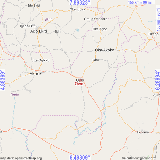
Owo GPS coordinates[2]
7° 11' 46.32" North, 5° 35' 12.516" East
| Map corner | latitude | longitude |
|---|---|---|
| Upper-left | 7.89323°, | 4.88369° |
| Center: | 7.1962°, | 5.58681° |
| Lower-right: | 6.49809°, | 6.28994° |
| Map W x H: | 155.1×155.1 km | = 96.4×96.4mi |
| max Lat: | 13.7543° ⇑66.1% North |
| Owo: | 7.1962° |
| min Lat: | ⇓33.9% South 4.31231° |
| min Long | Owo | max Long |
| 2.73333° | 5.58681° | 14.46552° |
| W 25.1%⇐ | ⇒74.9% E |
Elevation
Elevation of Owo is 348 m = 1142 ft, and this is 51.5 m = 169 ft above average elevation for this country.
| Max E: |
1599 m = 5246 ft | 39.7% |
| Owo | 348 m 1142 ft | |
| Avg. | 296.5 m = 973 ft | |
Min E: |
2 m = 7 ft | 60.3% |
See also: Owo elevation on elevation.city.
Geographical zone
Owo is located in North Torrid zone (between Equator and Tropic of Cancer). Distance of Equator is 800.1 km =497.2 mi to South.| Distance of | km | miles | from Owo |
|---|---|---|---|
| North Pole | 9206.9 | 5720.9 | to North |
| Arctic Circle | 6601 | 4101.7 | to North |
| Tropic Cancer | 1805.8 | 1122.1 | to North |
| Equator | 800.1 | 497.2 | to South |


Nearby cities:
15 places around Owo: (largest is in red/bold)
• Akure
43.9 km =27.3 mi,  278°
278°
• Emure-Ekiti
30.2 km =18.8 mi,  332°
332°
• Idanre
52.8 km =32.8 mi,  259°
259°
• Ifon
36.1 km =22.4 mi,  145°
145°
• Iju
42.3 km =26.3 mi,  301°
301°
• Ikare
41 km =25.5 mi,  26°
26°
• Ikere-Ekiti
51.6 km =32.1 mi,  310°
310°
• Ilare
55 km =34.2 mi,  288°
288°
• Ise-Ekiti
34.9 km =21.7 mi, 328°
• Isua
45.8 km =28.5 mi,  51°
51°
• Ita-Ogbolu
42.1 km =26.2 mi, 297°
• Ode-Ekiti
50.4 km =31.3 mi,  355°
355°
• Oka
37.7 km =23.4 mi,  38°
38°
• Oke-Agbe
53.2 km =33.1 mi,  20°
20°
• Sabongida-Ora
50.1 km =31.1 mi,  130°
130°
Sources, notices
• [Note1] Compared only with cities in Nigeria existing in our database
• [Src1] Map data: © OpenStreetMap contributors (CC-BY-SA)
• [Src2] Other city data from geonames.org with taken over terms of usage.
• [Src3] Geographical zone / Annual Mean Temperature by Robert A. Rohde @ Wikipedia
