Igarra geodata
Igarra (Edo) is a seat of a second-order administrative division; located in Nigeria in Africa/Lagos (GMT+1) time zone. With population of 14,647 people, there are 245 cities with bigger population in this country. Compared to other cities in Nigeria, 64.9% of cities are located further ↑North; 69.5% of cities are located further →East and 52.5% of cities have lower elevation than Igarra. Note1


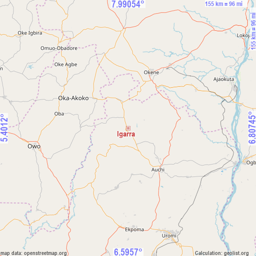
Igarra GPS coordinates[2]
7° 17' 37.176" North, 6° 6' 15.552" East
| Map corner | latitude | longitude |
|---|---|---|
| Upper-left | 7.99054°, | 5.4012° |
| Center: | 7.29366°, | 6.10432° |
| Lower-right: | 6.5957°, | 6.80745° |
| Map W x H: | 155.1×155.1 km | = 96.4×96.4mi |
| max Lat: | 13.7543° ⇑64.9% North |
| Igarra: | 7.29366° |
| min Lat: | ⇓35.1% South 4.31231° |
| min Long | Igarra | max Long |
| 2.73333° | 6.10432° | 14.46552° |
| W 30.5%⇐ | ⇒69.5% E |
Elevation
Elevation of Igarra is 296 m = 971 ft, and this is 0.5 m = 2 ft below average elevation for this country.
| Max E: |
1599 m = 5246 ft | 47.5% |
| Avg. | 296.5 m = 973 ft | |
| Igarra | 296 m = 971 ft | |
Min E: |
2 m = 7 ft | 52.5% |
See also: Nigeria elevation on elevation.city.
Geographical zone
Igarra is located in North Torrid zone (between Equator and Tropic of Cancer). Distance of Equator is 811 km =503.9 mi to South.| Distance of | km | miles | from Igarra |
|---|---|---|---|
| North Pole | 9196.1 | 5714.2 | to North |
| Arctic Circle | 6590.2 | 4095 | to North |
| Tropic Cancer | 1794.9 | 1115.3 | to North |
| Equator | 811 | 503.9 | to South |


Nearby cities:
15 places around Igarra: (largest is in red/bold)
• Adogo
47.9 km =29.8 mi,  59°
59°
• Afuze
36.7 km =22.8 mi,  190°
190°
• Akpafa
20.4 km =12.7 mi,  14°
14°
• Auchi
30.7 km =19.1 mi,  145°
145°
• Fugar
49 km =30.4 mi,  117°
117°
• Ifon
54.5 km =33.9 mi,  222°
222°
• Ikare
46.5 km =28.9 mi,  303°
303°
• Isua
27.8 km =17.3 mi,  309°
309°
• Obangede
37.8 km =23.5 mi,  16°
16°
• Ogaminana
35.7 km =22.2 mi, 20°
• Oka
38.2 km =23.7 mi, 299°
• Oke-Agbe
54.4 km =33.8 mi,  315°
315°
• Okene
32.1 km =19.9 mi,  26°
26°
• Owo
58.1 km =36.1 mi,  259°
259°
• Sabongida-Ora
47.5 km =29.5 mi,  203°
203°
Sources, notices
• [Note1] Compared only with cities in Nigeria existing in our database
• [Src1] Map data: © OpenStreetMap contributors (CC-BY-SA)
• [Src2] Other city data from geonames.org with taken over terms of usage.
• [Src3] Geographical zone / Annual Mean Temperature by Robert A. Rohde @ Wikipedia
