Ipetumodu geodata
Ipetumodu (Osun) is a seat of a second-order administrative division; located in Nigeria in Africa/Lagos (GMT+1) time zone. In our database, there are 451 cities with bigger population. Compared to other cities in Nigeria, 60.9% of cities are located further ↑North; 88% of cities are located further →East and 53.9% of cities have higher elevation than Ipetumodu. Note1


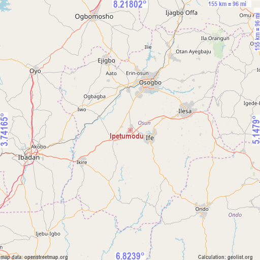
Ipetumodu GPS coordinates[2]
7° 31' 17.472" North, 4° 26' 41.172" East
| Map corner | latitude | longitude |
|---|---|---|
| Upper-left | 8.21802°, | 3.74165° |
| Center: | 7.52152°, | 4.44477° |
| Lower-right: | 6.8239°, | 5.1479° |
| Map W x H: | 155×155 km | = 96.3×96.3mi |
| max Lat: | 13.7543° ⇑60.9% North |
| Ipetumodu: | 7.52152° |
| min Lat: | ⇓39.1% South 4.31231° |
| min Long | Ipetumodu | max Long |
| 2.73333° | 4.44477° | 14.46552° |
| W 12%⇐ | ⇒88% E |
Elevation
Elevation of Ipetumodu is 255 m = 837 ft, and this is 41.5 m = 136 ft below average elevation for this country.
| Max E: |
1599 m = 5246 ft | 53.9% |
| Avg. | 296.5 m = 973 ft | |
| Ipetumodu | 255 m = 837 ft | |
Min E: |
2 m = 7 ft | 46.1% |
See also: Nigeria elevation on elevation.city.
Geographical zone
Ipetumodu is located in North Torrid zone (between Equator and Tropic of Cancer). Distance of Equator is 836.3 km =519.7 mi to South.| Distance of | km | miles | from Ipetumodu |
|---|---|---|---|
| North Pole | 9170.7 | 5698.4 | to North |
| Arctic Circle | 6564.9 | 4079.2 | to North |
| Tropic Cancer | 1769.6 | 1099.6 | to North |
| Equator | 836.3 | 519.7 | to South |


Nearby cities:
15 places around Ipetumodu: (largest is in red/bold)
• Apomu
34.5 km =21.4 mi,  236°
236°
• Awo
27.9 km =17.3 mi,  348°
348°
• Bode Osi
34.8 km =21.6 mi,  317°
317°
• Ede
23.9 km =14.9 mi,  357°
357°
• Gbongan
11.2 km =7 mi, 243°
• Ikire
33.1 km =20.6 mi, 239°
• Ile-Ife
13.5 km =8.4 mi,  108°
108°
• Ile-Ogbo
24.6 km =15.3 mi,  296°
296°
• Ilesa
34.8 km =21.6 mi,  70°
70°
• Ilobu
35.7 km =22.2 mi,  7°
7°
• Iwo
31.6 km =19.6 mi,  293°
293°
• Modakeke
25.5 km =15.8 mi,  232°
232°
• Olupona
30.1 km =18.7 mi, 286°
• Osogbo
30.4 km =18.9 mi,  24°
24°
• Osu
20.9 km =13 mi, 70°
Sources, notices
• [Note1] Compared only with cities in Nigeria existing in our database
• [Src1] Map data: © OpenStreetMap contributors (CC-BY-SA)
• [Src2] Other city data from geonames.org with taken over terms of usage.
• [Src3] Geographical zone / Annual Mean Temperature by Robert A. Rohde @ Wikipedia
