Ilesa geodata
Ilesa (Osun) is a seat of a second-order administrative division; located in Nigeria in Africa/Lagos (GMT+1) time zone. With population of 277,904 people, there are 30 cities with bigger population in this country. Compared to other cities in Nigeria, 58.8% of cities are located further ↑North; 84.6% of cities are located further →East and 66.2% of cities have lower elevation than Ilesa. Note1


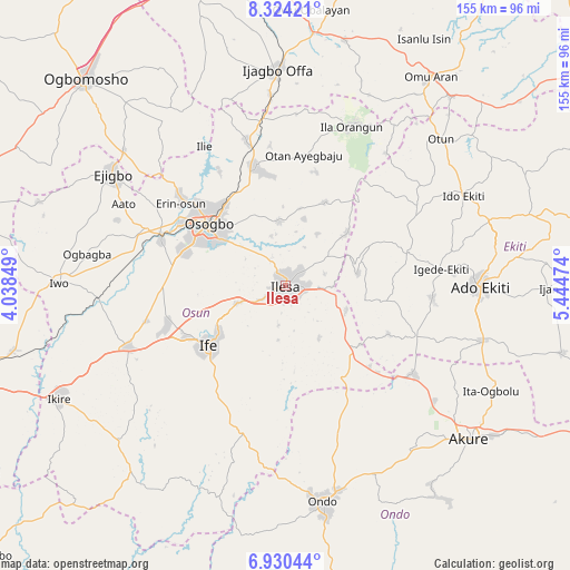
Ilesa GPS coordinates[2]
7° 37' 40.404" North, 4° 44' 29.796" East
| Map corner | latitude | longitude |
|---|---|---|
| Upper-left | 8.32421°, | 4.03849° |
| Center: | 7.62789°, | 4.74161° |
| Lower-right: | 6.93044°, | 5.44474° |
| Map W x H: | 155×155 km | = 96.3×96.3mi |
| max Lat: | 13.7543° ⇑58.8% North |
| Ilesa: | 7.62789° |
| min Lat: | ⇓41.2% South 4.31231° |
| min Long | Ilesa | max Long |
| 2.73333° | 4.74161° | 14.46552° |
| W 15.4%⇐ | ⇒84.6% E |
Elevation
Elevation of Ilesa is 377 m = 1237 ft, and this is 80.5 m = 264 ft above average elevation for this country.
| Max E: |
1599 m = 5246 ft | 33.8% |
| Ilesa | 377 m 1237 ft | |
| Avg. | 296.5 m = 973 ft | |
Min E: |
2 m = 7 ft | 66.2% |
See also: Ilesa elevation on elevation.city.
Geographical zone
Ilesa is located in North Torrid zone (between Equator and Tropic of Cancer). Distance of Equator is 848.1 km =527 mi to South.| Distance of | km | miles | from Ilesa |
|---|---|---|---|
| North Pole | 9158.9 | 5691.1 | to North |
| Arctic Circle | 6553 | 4071.8 | to North |
| Tropic Cancer | 1757.8 | 1092.2 | to North |
| Equator | 848.1 | 527 | to South |


Nearby cities:
15 places around Ilesa: (largest is in red/bold)
• Aramoko-Ekiti
34 km =21.1 mi,  75°
75°
• Ede
35.8 km =22.2 mi,  289°
289°
• Efon-Alaaye
20.2 km =12.6 mi, 80°
• Ibokun
17.8 km =11.1 mi,  355°
355°
• Ijebu-Jesa
10.4 km =6.5 mi,  53°
53°
• Ikirun
32.7 km =20.3 mi,  345°
345°
• Ile-Ife
25.7 km =16 mi,  231°
231°
• Ilobu
36.8 km =22.9 mi,  309°
309°
• Iperindo
16.8 km =10.4 mi,  146°
146°
• Ipetumodu
34.8 km =21.6 mi,  250°
250°
• Iragbiji
31.3 km =19.4 mi, 348°
• Oke Mesi
28.5 km =17.7 mi,  42°
42°
• Osogbo
25.8 km =16 mi, 308°
• Osu
13.9 km =8.6 mi, 250°
• Otan Ayegbaju
35.9 km =22.3 mi,  8°
8°
Sources, notices
• [Note1] Compared only with cities in Nigeria existing in our database
• [Src1] Map data: © OpenStreetMap contributors (CC-BY-SA)
• [Src2] Other city data from geonames.org with taken over terms of usage.
• [Src3] Geographical zone / Annual Mean Temperature by Robert A. Rohde @ Wikipedia
