Apomu geodata
Apomu (Osun) is a seat of a second-order administrative division; located in Nigeria in Africa/Lagos (GMT+1) time zone. With population of 71,656 people, there are 130 cities with bigger population in this country. Compared to other cities in Nigeria, 64.4% of cities are located further ↑North; 90.5% of cities are located further →East and 62.1% of cities have higher elevation than Apomu. Note1


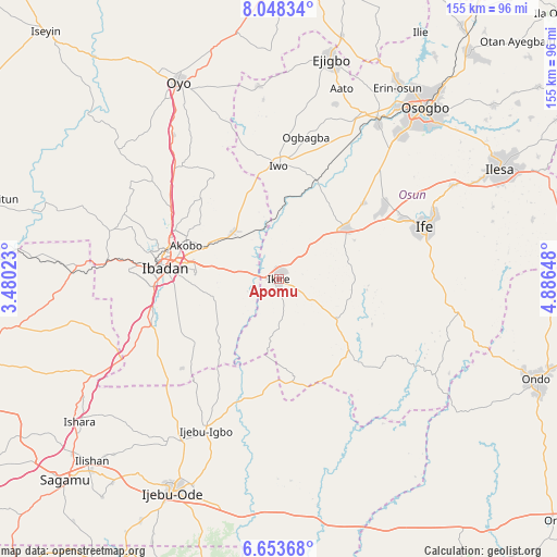
Apomu GPS coordinates[2]
7° 21' 5.616" North, 4° 11' 0.06" East
| Map corner | latitude | longitude |
|---|---|---|
| Upper-left | 8.04834°, | 3.48023° |
| Center: | 7.35156°, | 4.18335° |
| Lower-right: | 6.65368°, | 4.88648° |
| Map W x H: | 155.1×155.1 km | = 96.4×96.4mi |
| max Lat: | 13.7543° ⇑64.4% North |
| Apomu: | 7.35156° |
| min Lat: | ⇓35.6% South 4.31231° |
| min Long | Apomu | max Long |
| 2.73333° | 4.18335° | 14.46552° |
| W 9.5%⇐ | ⇒90.5% E |
Elevation
Elevation of Apomu is 193 m = 633 ft, and this is 103.5 m = 340 ft below average elevation for this country.
| Max E: |
1599 m = 5246 ft | 62.1% |
| Avg. | 296.5 m = 973 ft | |
| Apomu | 193 m = 633 ft | |
Min E: |
2 m = 7 ft | 37.9% |
See also: Apomu elevation on elevation.city.
Geographical zone
Apomu is located in North Torrid zone (between Equator and Tropic of Cancer). Distance of Equator is 817.4 km =507.9 mi to South.| Distance of | km | miles | from Apomu |
|---|---|---|---|
| North Pole | 9189.6 | 5710.2 | to North |
| Arctic Circle | 6583.8 | 4091 | to North |
| Tropic Cancer | 1788.5 | 1111.3 | to North |
| Equator | 817.4 | 507.9 | to South |


Nearby cities:
15 places around Apomu: (largest is in red/bold)
• Akanran
19.1 km =11.9 mi,  245°
245°
• Egbeda
15 km =9.3 mi,  280°
280°
• Gbongan
23.4 km =14.5 mi,  53°
53°
• Ibadan
30.7 km =19.1 mi, 275°
• Idi-Ayunre
37.9 km =23.5 mi, 249°
• Ikire
2.1 km =1.3 mi,  9°
9°
• Ile-Ife
44 km =27.3 mi,  70°
70°
• Ile-Ogbo
30.8 km =19.1 mi, 12°
• Ipetumodu
34.5 km =21.4 mi,  56°
56°
• Iwo
31.5 km =19.6 mi,  359°
359°
• Iyana-Ofa
19.9 km =12.4 mi,  325°
325°
• Lalupon
18.3 km =11.4 mi,  314°
314°
• Modakeke
9.2 km =5.7 mi, 67°
• Moniya
35.8 km =22.2 mi,  303°
303°
• Olupona
27.6 km =17.1 mi, 359°
Sources, notices
• [Note1] Compared only with cities in Nigeria existing in our database
• [Src1] Map data: © OpenStreetMap contributors (CC-BY-SA)
• [Src2] Other city data from geonames.org with taken over terms of usage.
• [Src3] Geographical zone / Annual Mean Temperature by Robert A. Rohde @ Wikipedia
