Ilobu geodata
Ilobu (Osun) is a seat of a second-order administrative division; located in Nigeria in Africa/Lagos (GMT+1) time zone. With population of 118,089 people, there are 71 cities with bigger population in this country. Compared to other cities in Nigeria, 55.5% of cities are located further ↑North; 87.5% of cities are located further →East and 58.2% of cities have lower elevation than Ilobu. Note1


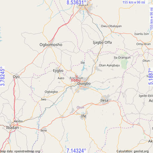
Ilobu GPS coordinates[2]
7° 50' 25.296" North, 4° 29' 8.052" East
| Map corner | latitude | longitude |
|---|---|---|
| Upper-left | 8.53631°, | 3.78245° |
| Center: | 7.84036°, | 4.48557° |
| Lower-right: | 7.14324°, | 5.1887° |
| Map W x H: | 154.9×154.9 km | = 96.3×96.3mi |
| max Lat: | 13.7543° ⇑55.5% North |
| Ilobu: | 7.84036° |
| min Lat: | ⇓44.5% South 4.31231° |
| min Long | Ilobu | max Long |
| 2.73333° | 4.48557° | 14.46552° |
| W 12.5%⇐ | ⇒87.5% E |
Elevation
Elevation of Ilobu is 334 m = 1096 ft, and this is 37.5 m = 123 ft above average elevation for this country.
| Max E: |
1599 m = 5246 ft | 41.8% |
| Ilobu | 334 m 1096 ft | |
| Avg. | 296.5 m = 973 ft | |
Min E: |
2 m = 7 ft | 58.2% |
See also: Ilobu elevation on elevation.city.
Geographical zone
Ilobu is located in North Torrid zone (between Equator and Tropic of Cancer). Distance of Equator is 871.8 km =541.7 mi to South.| Distance of | km | miles | from Ilobu |
|---|---|---|---|
| North Pole | 9135.3 | 5676.4 | to North |
| Arctic Circle | 6529.4 | 4057.2 | to North |
| Tropic Cancer | 1734.2 | 1077.6 | to North |
| Equator | 871.8 | 541.7 | to South |


Nearby cities:
15 places around Ilobu: (largest is in red/bold)
• Awo
12.8 km =8 mi,  230°
230°
• Bode Osi
29.9 km =18.6 mi,  250°
250°
• Ede
12.8 km =8 mi,  205°
205°
• Ejigbo
20.1 km =12.5 mi,  290°
290°
• Ibokun
27.5 km =17.1 mi,  102°
102°
• Ifon
2.4 km =1.5 mi,  334°
334°
• Ikirun
21.6 km =13.4 mi,  68°
68°
• Ilemona
35.6 km =22.1 mi,  32°
32°
• Inisa
16.8 km =10.4 mi,  273°
273°
• Iragbiji
23.3 km =14.5 mi, 72°
• Iresa-Adu
29.3 km =18.2 mi,  339°
339°
• Okuku
28.5 km =17.7 mi,  46°
46°
• Osogbo
11 km =6.8 mi,  134°
134°
• Osu
32.1 km =19.9 mi,  151°
151°
• Otan Ayegbaju
35.4 km =22 mi, 70°
Sources, notices
• [Note1] Compared only with cities in Nigeria existing in our database
• [Src1] Map data: © OpenStreetMap contributors (CC-BY-SA)
• [Src2] Other city data from geonames.org with taken over terms of usage.
• [Src3] Geographical zone / Annual Mean Temperature by Robert A. Rohde @ Wikipedia
