Efon-Alaaye geodata
Efon-Alaaye (Ekiti) is a seat of a second-order administrative division; located in Nigeria in Africa/Lagos (GMT+1) time zone. With population of 279,319 people, there are 29 cities with bigger population in this country. Compared to other cities in Nigeria, 58.2% of cities are located further ↑North; 82.1% of cities are located further →East and 90.1% of cities have lower elevation than Efon-Alaaye. Note1


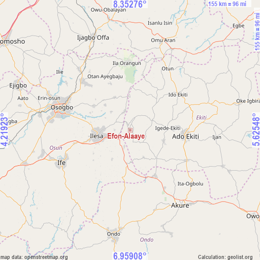
Efon-Alaaye GPS coordinates[2]
7° 39' 23.364" North, 4° 55' 20.46" East
| Map corner | latitude | longitude |
|---|---|---|
| Upper-left | 8.35276°, | 4.21923° |
| Center: | 7.65649°, | 4.92235° |
| Lower-right: | 6.95908°, | 5.62548° |
| Map W x H: | 155×155 km | = 96.3×96.3mi |
| max Lat: | 13.7543° ⇑58.2% North |
| Efon-Alaaye: | 7.65649° |
| min Lat: | ⇓41.8% South 4.31231° |
| min Long | Efon-Alaaye | max Long |
| 2.73333° | 4.92235° | 14.46552° |
| W 17.9%⇐ | ⇒82.1% E |
Elevation
Elevation of Efon-Alaaye is 556 m = 1824 ft, and this is 259.5 m = 851 ft above average elevation for this country.
| Max E: |
1599 m = 5246 ft | 9.9% |
| Efon-Alaaye | 556 m 1824 ft | |
| Avg. | 296.5 m = 973 ft | |
Min E: |
2 m = 7 ft | 90.1% |
See also: Efon-Alaaye elevation on elevation.city.
Geographical zone
Efon-Alaaye is located in North Torrid zone (between Equator and Tropic of Cancer). Distance of Equator is 851.3 km =529 mi to South.| Distance of | km | miles | from Efon-Alaaye |
|---|---|---|---|
| North Pole | 9155.7 | 5689.1 | to North |
| Arctic Circle | 6549.9 | 4069.9 | to North |
| Tropic Cancer | 1754.6 | 1090.3 | to North |
| Equator | 851.3 | 529 | to South |


Nearby cities:
15 places around Efon-Alaaye: (largest is in red/bold)
• Ado-Ekiti
33.1 km =20.6 mi,  96°
96°
• Aramoko-Ekiti
14.1 km =8.8 mi,  67°
67°
• Ibokun
25.7 km =16 mi,  304°
304°
• Igbara-Odo
23.1 km =14.4 mi,  137°
137°
• Igbara-Oke
31.1 km =19.3 mi,  151°
151°
• Igede-Ekiti
22.5 km =14 mi,  86°
86°
• Ijebu-Jesa
11.9 km =7.4 mi,  284°
284°
• Ijero-Ekiti
23.8 km =14.8 mi,  42°
42°
• Ilawe-Ekiti
21.1 km =13.1 mi,  107°
107°
• Ilesa
20.2 km =12.6 mi,  260°
260°
• Iperindo
20.2 km =12.6 mi,  211°
211°
• Ipoti
29.6 km =18.4 mi, 35°
• Oke Ila
33.3 km =20.7 mi,  11°
11°
• Oke Mesi
17.8 km =11.1 mi,  357°
357°
• Osu
34 km =21.1 mi, 256°
Sources, notices
• [Note1] Compared only with cities in Nigeria existing in our database
• [Src1] Map data: © OpenStreetMap contributors (CC-BY-SA)
• [Src2] Other city data from geonames.org with taken over terms of usage.
• [Src3] Geographical zone / Annual Mean Temperature by Robert A. Rohde @ Wikipedia
