Abeokuta geodata
Abeokuta (Ogun) is a seat of a first-order administrative division; located in Nigeria in Africa/Lagos (GMT+1) time zone. With population of 593,100 people, there are 13 cities with bigger population in this country. Compared to other cities in Nigeria, 67% of cities are located further ↑North; 97.5% of cities are located further →East and 84% of cities have higher elevation than Abeokuta. Note1


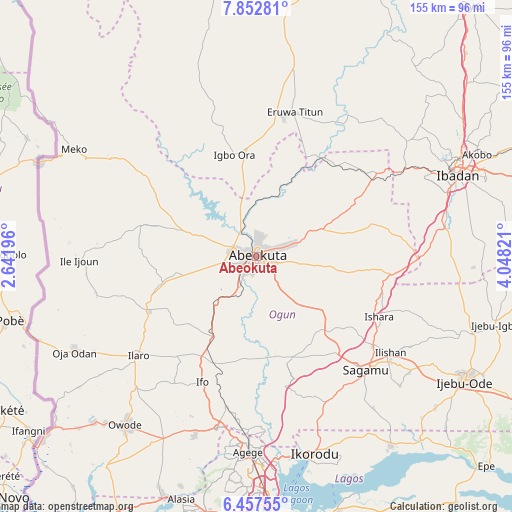
Abeokuta GPS coordinates[2]
7° 9' 20.556" North, 3° 20' 42.324" East
| Map corner | latitude | longitude |
|---|---|---|
| Upper-left | 7.85281°, | 2.64196° |
| Center: | 7.15571°, | 3.34509° |
| Lower-right: | 6.45755°, | 4.04821° |
| Map W x H: | 155.1×155.1 km | = 96.4×96.4mi |
| max Lat: | 13.7543° ⇑67% North |
| Abeokuta: | 7.15571° |
| min Lat: | ⇓33% South 4.31231° |
| min Long | Abeokuta | max Long |
| 2.73333° | 3.34509° | 14.46552° |
| W 2.5%⇐ | ⇒97.5% E |
Elevation
Elevation of Abeokuta is 64 m = 210 ft, and this is 232.5 m = 763 ft below average elevation for this country.
| Max E: |
1599 m = 5246 ft | 84% |
| Avg. | 296.5 m = 973 ft | |
| Abeokuta | 64 m = 210 ft | |
Min E: |
2 m = 7 ft | 16% |
See also: Abeokuta elevation on elevation.city.
Geographical zone
Abeokuta is located in North Torrid zone (between Equator and Tropic of Cancer). Distance of Equator is 795.6 km =494.4 mi to South.| Distance of | km | miles | from Abeokuta |
|---|---|---|---|
| North Pole | 9211.4 | 5723.7 | to North |
| Arctic Circle | 6605.5 | 4104.5 | to North |
| Tropic Cancer | 1810.3 | 1124.9 | to North |
| Equator | 795.6 | 494.4 | to South |


Nearby cities:
15 places around Abeokuta: (largest is in red/bold)
• Ayete
45.1 km =28 mi,  342°
342°
• Ayetoro
36.5 km =22.7 mi,  285°
285°
• Eruwa
42.8 km =26.6 mi,  10°
10°
• Ifo
41.3 km =25.7 mi,  203°
203°
• Igbo-Ora
31.6 km =19.6 mi,  348°
348°
• Ikenne
52 km =32.3 mi,  128°
128°
• Ilaro
47 km =29.2 mi,  230°
230°
• Iperu
44.7 km =27.8 mi, 127°
• Isara
41.3 km =25.7 mi,  115°
115°
• Itori
28.4 km =17.6 mi,  208°
208°
• Odeda
21.9 km =13.6 mi,  67°
67°
• Orita Eruwa
44.9 km =27.9 mi, 12°
• Ota
53.4 km =33.2 mi,  193°
193°
• Owode
29.1 km =18.1 mi,  142°
142°
• Shagamu
47.7 km =29.6 mi, 135°
Sources, notices
• [Note1] Compared only with cities in Nigeria existing in our database
• [Src1] Map data: © OpenStreetMap contributors (CC-BY-SA)
• [Src2] Other city data from geonames.org with taken over terms of usage.
• [Src3] Geographical zone / Annual Mean Temperature by Robert A. Rohde @ Wikipedia
