Ikang geodata
Ikang (Cross River) is a populated place; located in Nigeria in Africa/Lagos (GMT+1) time zone. With population of 13,305 people, there are 268 cities with bigger population in this country. Compared to other cities in Nigeria, 96.9% of cities are located further ↑North; 72.3% of cities are located further ←West and 96.6% of cities have higher elevation than Ikang. Note1


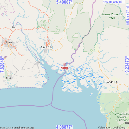
Ikang GPS coordinates[2]
4° 47' 23.208" North, 8° 31' 53.76" East
| Map corner | latitude | longitude |
|---|---|---|
| Upper-left | 5.49007°, | 7.82848° |
| Center: | 4.78978°, | 8.5316° |
| Lower-right: | 4.08877°, | 9.23473° |
| Map W x H: | 155.8×155.8 km | = 96.8×96.8mi |
| max Lat: | 13.7543° ⇑96.9% North |
| Ikang: | 4.78978° |
| min Lat: | ⇓3.1% South 4.31231° |
| min Long | Ikang | max Long |
| 2.73333° | 8.5316° | 14.46552° |
| W 72.3%⇐ | ⇒27.7% E |
Elevation
Elevation of Ikang is 9 m = 30 ft, and this is 287.5 m = 943 ft below average elevation for this country.
| Max E: |
1599 m = 5246 ft | 96.6% |
| Avg. | 296.5 m = 973 ft | |
| Ikang | 9 m = 30 ft | |
Min E: |
2 m = 7 ft | 3.4% |
See also: Nigeria elevation on elevation.city.
Geographical zone
Ikang is located in North Torrid zone (between Equator and Tropic of Cancer). Distance of Equator is 532.6 km =330.9 mi to South.| Distance of | km | miles | from Ikang |
|---|---|---|---|
| North Pole | 9474.5 | 5887.2 | to North |
| Arctic Circle | 6868.6 | 4267.9 | to North |
| Tropic Cancer | 2073.3 | 1288.3 | to North |
| Equator | 532.6 | 330.9 | to South |


Nearby cities:
15 places around Ikang: (largest is in red/bold)
• Akamkpa
61.3 km =38.1 mi,  341°
341°
• Akankpa
53.2 km =33.1 mi,  314°
314°
• Calabar
29.5 km =18.3 mi, 309°
• Enwang
34.3 km =21.3 mi,  244°
244°
• Esuk Oron
30.9 km =19.2 mi,  272°
272°
• Eyofin
33.6 km =20.9 mi,  262°
262°
• Idu
62.9 km =39.1 mi,  295°
295°
• Ikot Nakanda
11.8 km =7.3 mi,  333°
333°
• Nung Udoe
64.5 km =40.1 mi,  282°
282°
• Odot
54.8 km =34.1 mi, 274°
• Odukpani
43.8 km =27.2 mi, 330°
• Okopedi
45.5 km =28.3 mi, 278°
• Oron
33 km =20.5 mi, 276°
• Uquo
54.4 km =33.8 mi,  254°
254°
• Urue Offong
40.5 km =25.2 mi, 264°
Sources, notices
• [Note1] Compared only with cities in Nigeria existing in our database
• [Src1] Map data: © OpenStreetMap contributors (CC-BY-SA)
• [Src2] Other city data from geonames.org with taken over terms of usage.
• [Src3] Geographical zone / Annual Mean Temperature by Robert A. Rohde @ Wikipedia
