Owerri geodata
Owerri (Imo) is a seat of a first-order administrative division; located in Nigeria in Africa/Lagos (GMT+1) time zone. With population of 215,038 people, there are 42 cities with bigger population in this country. Compared to other cities in Nigeria, 89.9% of cities are located further ↑North; 55.8% of cities are located further →East and 81.8% of cities have higher elevation than Owerri. Note1


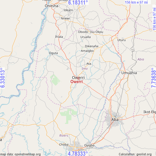
Owerri GPS coordinates[2]
5° 29' 1.068" North, 7° 1' 59.7" East
| Map corner | latitude | longitude |
|---|---|---|
| Upper-left | 6.18311°, | 6.33013° |
| Center: | 5.48363°, | 7.03325° |
| Lower-right: | 4.78333°, | 7.73638° |
| Map W x H: | 155.6×155.6 km | = 96.7×96.7mi |
| max Lat: | 13.7543° ⇑89.9% North |
| Owerri: | 5.48363° |
| min Lat: | ⇓10.1% South 4.31231° |
| min Long | Owerri | max Long |
| 2.73333° | 7.03325° | 14.46552° |
| W 44.2%⇐ | ⇒55.8% E |
Elevation
Elevation of Owerri is 73 m = 240 ft, and this is 223.5 m = 733 ft below average elevation for this country.
| Max E: |
1599 m = 5246 ft | 81.8% |
| Avg. | 296.5 m = 973 ft | |
| Owerri | 73 m = 240 ft | |
Min E: |
2 m = 7 ft | 18.2% |
See also: Owerri elevation on elevation.city.
Geographical zone
Owerri is located in North Torrid zone (between Equator and Tropic of Cancer). Distance of Equator is 609.7 km =378.8 mi to South.| Distance of | km | miles | from Owerri |
|---|---|---|---|
| North Pole | 9397.3 | 5839.2 | to North |
| Arctic Circle | 6791.5 | 4220 | to North |
| Tropic Cancer | 1996.2 | 1240.4 | to North |
| Equator | 609.7 | 378.8 | to South |


Nearby cities:
15 places around Owerri: (largest is in red/bold)
• Aboh
26.4 km =16.4 mi,  91°
91°
• Afor-Oru
26.8 km =16.7 mi,  76°
76°
• Amaigbo
28.9 km =18 mi,  18°
18°
• Egbema
30.9 km =19.2 mi,  282°
282°
• Iho
13.2 km =8.2 mi,  33°
33°
• Mgbidi
31.9 km =19.8 mi,  329°
329°
• Nkwerre
31.6 km =19.6 mi,  14°
14°
• Nnenasa
27.8 km =17.3 mi,  355°
355°
• Nwaorieubi
11.1 km =6.9 mi,  350°
350°
• Orodo
14.8 km =9.2 mi,  0°
0°
• Umuelemai
32.5 km =20.2 mi,  45°
45°
• Umuguma
7.7 km =4.8 mi,  256°
256°
• Umumma
31.9 km =19.8 mi,  342°
342°
• Umundugba
21.8 km =13.5 mi, 11°
• Umuneke-Ngor
21.1 km =13.1 mi,  141°
141°
Sources, notices
• [Note1] Compared only with cities in Nigeria existing in our database
• [Src1] Map data: © OpenStreetMap contributors (CC-BY-SA)
• [Src2] Other city data from geonames.org with taken over terms of usage.
• [Src3] Geographical zone / Annual Mean Temperature by Robert A. Rohde @ Wikipedia
