Aboh geodata
Aboh (Imo) is a seat of a second-order administrative division; located in Nigeria in Africa/Lagos (GMT+1) time zone. In our database, there are 451 cities with bigger population. Compared to other cities in Nigeria, 90.1% of cities are located further ↑North; 50.9% of cities are located further →East and 71.6% of cities have higher elevation than Aboh. Note1


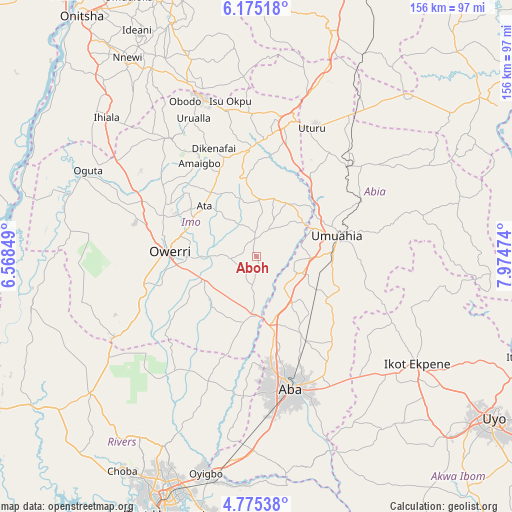
Aboh GPS coordinates[2]
5° 28' 32.484" North, 7° 16' 17.796" East
| Map corner | latitude | longitude |
|---|---|---|
| Upper-left | 6.17518°, | 6.56849° |
| Center: | 5.47569°, | 7.27161° |
| Lower-right: | 4.77538°, | 7.97474° |
| Map W x H: | 155.6×155.6 km | = 96.7×96.7mi |
| max Lat: | 13.7543° ⇑90.1% North |
| Aboh: | 5.47569° |
| min Lat: | ⇓9.9% South 4.31231° |
| min Long | Aboh | max Long |
| 2.73333° | 7.27161° | 14.46552° |
| W 49.1%⇐ | ⇒50.9% E |
Elevation
Elevation of Aboh is 139 m = 456 ft, and this is 157.5 m = 517 ft below average elevation for this country.
| Max E: |
1599 m = 5246 ft | 71.6% |
| Avg. | 296.5 m = 973 ft | |
| Aboh | 139 m = 456 ft | |
Min E: |
2 m = 7 ft | 28.4% |
See also: Nigeria elevation on elevation.city.
Geographical zone
Aboh is located in North Torrid zone (between Equator and Tropic of Cancer). Distance of Equator is 608.8 km =378.3 mi to South.| Distance of | km | miles | from Aboh |
|---|---|---|---|
| North Pole | 9398.2 | 5839.8 | to North |
| Arctic Circle | 6792.3 | 4220.5 | to North |
| Tropic Cancer | 1997.1 | 1240.9 | to North |
| Equator | 608.8 | 378.3 | to South |


Nearby cities:
15 places around Aboh: (largest is in red/bold)
• Afor-Oru
7.3 km =4.5 mi,  357°
357°
• Amaigbo
33.2 km =20.6 mi,  328°
328°
• Iho
22.5 km =14 mi,  301°
301°
• Isiala Oboro
33.7 km =20.9 mi,  103°
103°
• Isinweke
18.3 km =11.4 mi,  28°
28°
• Itu
6.7 km =4.2 mi, 101°
• Nwaorieubi
30.6 km =19 mi,  292°
292°
• Okpuala-Ngwa
18.4 km =11.4 mi,  135°
135°
• Omoba
29.9 km =18.6 mi,  150°
150°
• Orodo
30.7 km =19.1 mi, 300°
• Owerri
26.4 km =16.4 mi,  271°
271°
• Umuahia
25.3 km =15.7 mi,  77°
77°
• Umuelemai
23.8 km =14.8 mi,  352°
352°
• Umundugba
31.4 km =19.5 mi,  315°
315°
• Umuneke-Ngor
20.5 km =12.7 mi,  220°
220°
Sources, notices
• [Note1] Compared only with cities in Nigeria existing in our database
• [Src1] Map data: © OpenStreetMap contributors (CC-BY-SA)
• [Src2] Other city data from geonames.org with taken over terms of usage.
• [Src3] Geographical zone / Annual Mean Temperature by Robert A. Rohde @ Wikipedia
