Auchi geodata
Auchi (Edo) is a seat of a second-order administrative division; located in Nigeria in Africa/Lagos (GMT+1) time zone. With population of 62,907 people, there are 143 cities with bigger population in this country. Compared to other cities in Nigeria, 68.1% of cities are located further ↑North; 67% of cities are located further →East and 63.1% of cities have higher elevation than Auchi. Note1


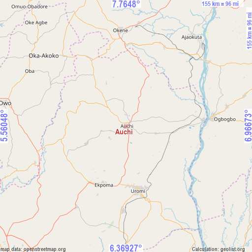
Auchi GPS coordinates[2]
7° 4' 3.216" North, 6° 15' 48.96" East
| Map corner | latitude | longitude |
|---|---|---|
| Upper-left | 7.7648°, | 5.56048° |
| Center: | 7.06756°, | 6.2636° |
| Lower-right: | 6.36927°, | 6.96673° |
| Map W x H: | 155.2×155.2 km | = 96.4×96.4mi |
| max Lat: | 13.7543° ⇑68.1% North |
| Auchi: | 7.06756° |
| min Lat: | ⇓31.9% South 4.31231° |
| min Long | Auchi | max Long |
| 2.73333° | 6.2636° | 14.46552° |
| W 33%⇐ | ⇒67% E |
Elevation
Elevation of Auchi is 188 m = 617 ft, and this is 108.5 m = 356 ft below average elevation for this country.
| Max E: |
1599 m = 5246 ft | 63.1% |
| Avg. | 296.5 m = 973 ft | |
| Auchi | 188 m = 617 ft | |
Min E: |
2 m = 7 ft | 36.9% |
See also: Auchi elevation on elevation.city.
Geographical zone
Auchi is located in North Torrid zone (between Equator and Tropic of Cancer). Distance of Equator is 785.8 km =488.3 mi to South.| Distance of | km | miles | from Auchi |
|---|---|---|---|
| North Pole | 9221.2 | 5729.8 | to North |
| Arctic Circle | 6615.3 | 4110.6 | to North |
| Tropic Cancer | 1820.1 | 1131 | to North |
| Equator | 785.8 | 488.3 | to South |


Nearby cities:
15 places around Auchi: (largest is in red/bold)
• Adogo
54.7 km =34 mi,  25°
25°
• Afuze
26.7 km =16.6 mi,  245°
245°
• Agenebode
47.7 km =29.6 mi,  84°
84°
• Akpafa
46.7 km =29 mi,  344°
344°
• Ekpoma
38.6 km =24 mi,  200°
200°
• Fugar
26 km =16.2 mi, 84°
• Idah
52.7 km =32.7 mi, 84°
• Igarra
30.7 km =19.1 mi,  325°
325°
• Igueben
51.8 km =32.2 mi,  182°
182°
• Irrua
37.1 km =23.1 mi,  187°
187°
• Okene
53.9 km =33.5 mi,  356°
356°
• Onyedega
50 km =31.1 mi,  114°
114°
• Sabongida-Ora
41 km =25.5 mi,  243°
243°
• Ubiaja
47.7 km =29.6 mi,  163°
163°
• Uromi
41.6 km =25.8 mi,  169°
169°
Sources, notices
• [Note1] Compared only with cities in Nigeria existing in our database
• [Src1] Map data: © OpenStreetMap contributors (CC-BY-SA)
• [Src2] Other city data from geonames.org with taken over terms of usage.
• [Src3] Geographical zone / Annual Mean Temperature by Robert A. Rohde @ Wikipedia
