Ifon geodata
Ifon (Ondo) is a seat of a second-order administrative division; located in Nigeria in Africa/Lagos (GMT+1) time zone. With population of 7,623 people, there are 394 cities with bigger population in this country. Compared to other cities in Nigeria, 69.2% of cities are located further ↑North; 73% of cities are located further →East and 63.9% of cities have higher elevation than Ifon. Note1


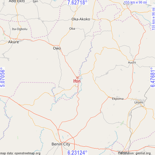
Ifon GPS coordinates[2]
6° 55' 47.028" North, 5° 46' 25.248" East
| Map corner | latitude | longitude |
|---|---|---|
| Upper-left | 7.62718°, | 5.07056° |
| Center: | 6.92973°, | 5.77368° |
| Lower-right: | 6.23124°, | 6.47681° |
| Map W x H: | 155.2×155.2 km | = 96.4×96.4mi |
| max Lat: | 13.7543° ⇑69.2% North |
| Ifon: | 6.92973° |
| min Lat: | ⇓30.8% South 4.31231° |
| min Long | Ifon | max Long |
| 2.73333° | 5.77368° | 14.46552° |
| W 27%⇐ | ⇒73% E |
Elevation
Elevation of Ifon is 184 m = 604 ft, and this is 112.5 m = 369 ft below average elevation for this country.
| Max E: |
1599 m = 5246 ft | 63.9% |
| Avg. | 296.5 m = 973 ft | |
| Ifon | 184 m = 604 ft | |
Min E: |
2 m = 7 ft | 36.1% |
See also: Nigeria elevation on elevation.city.
Geographical zone
Ifon is located in North Torrid zone (between Equator and Tropic of Cancer). Distance of Equator is 770.5 km =478.8 mi to South.| Distance of | km | miles | from Ifon |
|---|---|---|---|
| North Pole | 9236.5 | 5739.3 | to North |
| Arctic Circle | 6630.7 | 4120.1 | to North |
| Tropic Cancer | 1835.4 | 1140.5 | to North |
| Equator | 770.5 | 478.8 | to South |


Nearby cities:
15 places around Ifon: (largest is in red/bold)
• Afuze
30 km =18.6 mi,  81°
81°
• Auchi
56.2 km =34.9 mi,  74°
74°
• Ehor
41.9 km =26 mi,  146°
146°
• Ekpoma
45.5 km =28.3 mi,  117°
117°
• Emure-Ekiti
66.2 km =41.1 mi,  328°
328°
• Igarra
54.5 km =33.9 mi,  42°
42°
• Igueben
63.3 km =39.3 mi,  125°
125°
• Iguobazuwa
61.5 km =38.2 mi,  228°
228°
• Irrua
53.7 km =33.4 mi,  113°
113°
• Isua
60.2 km =37.4 mi,  14°
14°
• Oka
59.1 km =36.7 mi,  3°
3°
• Okada
47.1 km =29.3 mi,  242°
242°
• Owo
36.1 km =22.4 mi, 325°
• Sabongida-Ora
17.6 km =10.9 mi,  99°
99°
• Uselu
63.3 km =39.3 mi,  196°
196°
Sources, notices
• [Note1] Compared only with cities in Nigeria existing in our database
• [Src1] Map data: © OpenStreetMap contributors (CC-BY-SA)
• [Src2] Other city data from geonames.org with taken over terms of usage.
• [Src3] Geographical zone / Annual Mean Temperature by Robert A. Rohde @ Wikipedia
