Hinna geodata
Hinna (Gombe) is a populated place; located in Nigeria in Africa/Lagos (GMT+1) time zone. With population of 7,826 people, there are 389 cities with bigger population in this country. Compared to other cities in Nigeria, 66.9% of cities are located further ↓South; 92% of cities are located further ←West and 58.5% of cities have higher elevation than Hinna. Note1


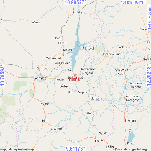
Hinna GPS coordinates[2]
10° 18' 15.336" North, 11° 29' 56.58" East
| Map corner | latitude | longitude |
|---|---|---|
| Upper-left | 10.99527°, | 10.79593° |
| Center: | 10.30426°, | 11.49905° |
| Lower-right: | 9.61173°, | 12.20218° |
| Map W x H: | 153.8×153.8 km | = 95.6×95.6mi |
| max Lat: | 13.7543° ⇑33.1% North |
| Hinna: | 10.30426° |
| min Lat: | ⇓66.9% South 4.31231° |
| min Long | Hinna | max Long |
| 2.73333° | 11.49905° | 14.46552° |
| W 92%⇐ | ⇒8% E |
Elevation
Elevation of Hinna is 221 m = 725 ft, and this is 75.5 m = 248 ft below average elevation for this country.
| Max E: |
1599 m = 5246 ft | 58.5% |
| Avg. | 296.5 m = 973 ft | |
| Hinna | 221 m = 725 ft | |
Min E: |
2 m = 7 ft | 41.5% |
See also: Nigeria elevation on elevation.city.
Geographical zone
Hinna is located in North Torrid zone (between Equator and Tropic of Cancer). Distance of Equator is 1145.7 km =711.9 mi to South.| Distance of | km | miles | from Hinna |
|---|---|---|---|
| North Pole | 8861.3 | 5506.2 | to North |
| Arctic Circle | 6255.4 | 3886.9 | to North |
| Tropic Cancer | 1460.2 | 907.3 | to North |
| Equator | 1145.7 | 711.9 | to South |


Nearby cities:
15 places around Hinna: (largest is in red/bold)
• Akko
57.6 km =35.8 mi,  268°
268°
• Bajoga
61.3 km =38.1 mi,  353°
353°
• Billiri
55.4 km =34.4 mi,  213°
213°
• Billiri
57.2 km =35.5 mi, 211°
• Briyel
13 km =8.1 mi,  68°
68°
• Deba
16 km =9.9 mi,  230°
230°
• Garko
39.3 km =24.4 mi,  248°
248°
• Gombe
36.3 km =22.6 mi, 267°
• Kafarati
45 km =28 mi,  281°
281°
• Kaltungo
57.7 km =35.9 mi,  201°
201°
• Kumo
42.5 km =26.4 mi, 227°
• Kwaya Kusar
43.7 km =27.2 mi,  59°
59°
• Mallam Sidi
29 km =18 mi,  308°
308°
• Talasse
42.2 km =26.2 mi,  152°
152°
• Wuyo
23.4 km =14.5 mi, 67°
Sources, notices
• [Note1] Compared only with cities in Nigeria existing in our database
• [Src1] Map data: © OpenStreetMap contributors (CC-BY-SA)
• [Src2] Other city data from geonames.org with taken over terms of usage.
• [Src3] Geographical zone / Annual Mean Temperature by Robert A. Rohde @ Wikipedia
