Talasse geodata
Talasse (Gombe) is a seat of a second-order administrative division; located in Nigeria in Africa/Lagos (GMT+1) time zone. In our database, there are 451 cities with bigger population. Compared to other cities in Nigeria, 64% of cities are located further ↓South; 92.5% of cities are located further ←West and 52.9% of cities have lower elevation than Talasse. Note1


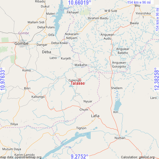
Talasse GPS coordinates[2]
9° 58' 6.348" North, 11° 40' 46.02" East
| Map corner | latitude | longitude |
|---|---|---|
| Upper-left | 10.66019°, | 10.97633° |
| Center: | 9.96843°, | 11.67945° |
| Lower-right: | 9.2752°, | 12.38258° |
| Map W x H: | 154×154 km | = 95.7×95.7mi |
| max Lat: | 13.7543° ⇑36% North |
| Talasse: | 9.96843° |
| min Lat: | ⇓64% South 4.31231° |
| min Long | Talasse | max Long |
| 2.73333° | 11.67945° | 14.46552° |
| W 92.5%⇐ | ⇒7.5% E |
Elevation
Elevation of Talasse is 297 m = 974 ft, and this is 0.5 m = 2 ft above average elevation for this country.
| Max E: |
1599 m = 5246 ft | 47.1% |
| Talasse | 297 m 974 ft | |
| Avg. | 296.5 m = 973 ft | |
Min E: |
2 m = 7 ft | 52.9% |
See also: Nigeria elevation on elevation.city.
Geographical zone
Talasse is located in North Torrid zone (between Equator and Tropic of Cancer). Distance of Equator is 1108.4 km =688.7 mi to South.| Distance of | km | miles | from Talasse |
|---|---|---|---|
| North Pole | 8898.7 | 5529.4 | to North |
| Arctic Circle | 6292.8 | 3910.2 | to North |
| Tropic Cancer | 1497.5 | 930.5 | to North |
| Equator | 1108.4 | 688.7 | to South |


Nearby cities:
15 places around Talasse: (largest is in red/bold)
• Billiri
50.9 km =31.6 mi,  257°
257°
• Billiri
51.3 km =31.9 mi, 260°
• Boh
48.5 km =30.1 mi,  244°
244°
• Briyel
42.8 km =26.6 mi,  349°
349°
• Dadiya
47.5 km =29.5 mi,  214°
214°
• Deba
41.9 km =26 mi,  310°
310°
• Garko
60.9 km =37.8 mi,  292°
292°
• Guyuk
28 km =17.4 mi,  104°
104°
• Hinna
42.2 km =26.2 mi,  332°
332°
• Kaltungo
43.8 km =27.2 mi,  247°
247°
• Kumo
52.1 km =32.4 mi,  279°
279°
• Lamurde
42 km =26.1 mi,  162°
162°
• Shani
50.1 km =31.1 mi,  56°
56°
• Shelleng
36.6 km =22.7 mi, 102°
• Wuyo
46.4 km =28.8 mi,  2°
2°
Sources, notices
• [Note1] Compared only with cities in Nigeria existing in our database
• [Src1] Map data: © OpenStreetMap contributors (CC-BY-SA)
• [Src2] Other city data from geonames.org with taken over terms of usage.
• [Src3] Geographical zone / Annual Mean Temperature by Robert A. Rohde @ Wikipedia
