Mubi geodata
Mubi (Adamawa) is a seat of a second-order administrative division; located in Nigeria in Africa/Lagos (GMT+1) time zone. With population of 225,705 people, there are 40 cities with bigger population in this country. Compared to other cities in Nigeria, 66.5% of cities are located further ↓South; 98.1% of cities are located further ←West and 92% of cities have lower elevation than Mubi. Note1


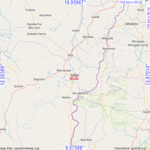
Mubi GPS coordinates[2]
10° 16' 6.888" North, 13° 16' 1.236" East
| Map corner | latitude | longitude |
|---|---|---|
| Upper-left | 10.95967°, | 12.56389° |
| Center: | 10.26858°, | 13.26701° |
| Lower-right: | 9.57598°, | 13.97014° |
| Map W x H: | 153.9×153.9 km | = 95.6×95.6mi |
| max Lat: | 13.7543° ⇑33.5% North |
| Mubi: | 10.26858° |
| min Lat: | ⇓66.5% South 4.31231° |
| min Long | Mubi | max Long |
| 2.73333° | 13.26701° | 14.46552° |
| W 98.1%⇐ | ⇒1.9% E |
Elevation
Elevation of Mubi is 582 m = 1909 ft, and this is 285.5 m = 937 ft above average elevation for this country.
| Max E: |
1599 m = 5246 ft | 8% |
| Mubi | 582 m 1909 ft | |
| Avg. | 296.5 m = 973 ft | |
Min E: |
2 m = 7 ft | 92% |
See also: Mubi elevation on elevation.city.
Geographical zone
Mubi is located in North Torrid zone (between Equator and Tropic of Cancer). Distance of Equator is 1141.8 km =709.5 mi to South.| Distance of | km | miles | from Mubi |
|---|---|---|---|
| North Pole | 8865.3 | 5508.6 | to North |
| Arctic Circle | 6259.4 | 3889.4 | to North |
| Tropic Cancer | 1464.2 | 909.8 | to North |
| Equator | 1141.8 | 709.5 | to South |


Nearby cities:
15 places around Mubi: (largest is in red/bold)
• Askira
57.8 km =35.9 mi,  317°
317°
• Chibok
81.1 km =50.4 mi,  325°
325°
• Gella
12.9 km =8 mi,  163°
163°
• Gombi
59.1 km =36.7 mi,  259°
259°
• Gulak
63.2 km =39.3 mi,  19°
19°
• Gwoza
102 km =63.4 mi,  27°
27°
• Holma
47.3 km =29.4 mi,  209°
209°
• Hong
37.3 km =23.2 mi, 263°
• Madagali
79.5 km =49.4 mi, 29°
• Maiha
30.7 km =19.1 mi,  190°
190°
• Michika
41.3 km =25.7 mi, 18°
• Shaffa
105.5 km =65.6 mi,  284°
284°
• Song
85.9 km =53.4 mi,  235°
235°
• Tokombere
108.6 km =67.5 mi,  12°
12°
• Uba
21.3 km =13.2 mi,  346°
346°
Sources, notices
• [Note1] Compared only with cities in Nigeria existing in our database
• [Src1] Map data: © OpenStreetMap contributors (CC-BY-SA)
• [Src2] Other city data from geonames.org with taken over terms of usage.
• [Src3] Geographical zone / Annual Mean Temperature by Robert A. Rohde @ Wikipedia
