Ikara geodata
Ikara (Kaduna) is a seat of a second-order administrative division; located in Nigeria in Africa/Lagos (GMT+1) time zone. In our database, there are 451 cities with bigger population. Compared to other cities in Nigeria, 73.8% of cities are located further ↓South; 67.1% of cities are located further ←West and 95.4% of cities have lower elevation than Ikara. Note1


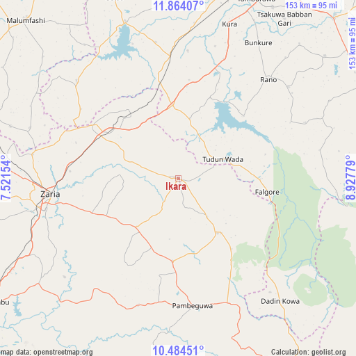
Ikara GPS coordinates[2]
11° 10' 30.396" North, 8° 13' 28.776" East
| Map corner | latitude | longitude |
|---|---|---|
| Upper-left | 11.86407°, | 7.52154° |
| Center: | 11.17511°, | 8.22466° |
| Lower-right: | 10.48451°, | 8.92779° |
| Map W x H: | 153.4×153.4 km | = 95.3×95.3mi |
| max Lat: | 13.7543° ⇑26.2% North |
| Ikara: | 11.17511° |
| min Lat: | ⇓73.8% South 4.31231° |
| min Long | Ikara | max Long |
| 2.73333° | 8.22466° | 14.46552° |
| W 67.1%⇐ | ⇒32.9% E |
Elevation
Elevation of Ikara is 667 m = 2188 ft, and this is 370.5 m = 1216 ft above average elevation for this country.
| Max E: |
1599 m = 5246 ft | 4.6% |
| Ikara | 667 m 2188 ft | |
| Avg. | 296.5 m = 973 ft | |
Min E: |
2 m = 7 ft | 95.4% |
See also: Nigeria elevation on elevation.city.
Geographical zone
Ikara is located in North Torrid zone (between Equator and Tropic of Cancer). Distance of Equator is 1242.6 km =772.1 mi to South.| Distance of | km | miles | from Ikara |
|---|---|---|---|
| North Pole | 8764.5 | 5446 | to North |
| Arctic Circle | 6158.6 | 3826.8 | to North |
| Tropic Cancer | 1363.4 | 847.2 | to North |
| Equator | 1242.6 | 772.1 | to South |


Nearby cities:
15 places around Ikara: (largest is in red/bold)
• Anchau
29.9 km =18.6 mi,  142°
142°
• Bebeji
54.9 km =34.1 mi,  4°
4°
• Burumburum
59.4 km =36.9 mi,  66°
66°
• Dan Gora
40.8 km =25.4 mi,  348°
348°
• Dutsen Wai
36.2 km =22.5 mi,  184°
184°
• Garun Malam
58.9 km =36.6 mi,  15°
15°
• Kibiya
61.7 km =38.3 mi,  50°
50°
• Kiru
59.4 km =36.9 mi, 350°
• Maigana
35.3 km =21.9 mi,  242°
242°
• Makarfi
43.7 km =27.2 mi,  300°
300°
• Rano
57.5 km =35.7 mi,  42°
42°
• Rogo
60.7 km =37.7 mi,  313°
313°
• Soba
28.2 km =17.5 mi,  220°
220°
• Tudun Wada
20.9 km =13 mi, 67°
• Zaria
55.2 km =34.3 mi,  262°
262°
Sources, notices
• [Note1] Compared only with cities in Nigeria existing in our database
• [Src1] Map data: © OpenStreetMap contributors (CC-BY-SA)
• [Src2] Other city data from geonames.org with taken over terms of usage.
• [Src3] Geographical zone / Annual Mean Temperature by Robert A. Rohde @ Wikipedia
