Rogo geodata
Rogo (Kano) is a seat of a second-order administrative division; located in Nigeria in Africa/Lagos (GMT+1) time zone. In our database, there are 451 cities with bigger population. Compared to other cities in Nigeria, 78.5% of cities are located further ↓South; 60.3% of cities are located further ←West and 93.4% of cities have lower elevation than Rogo. Note1


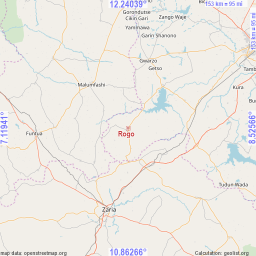
Rogo GPS coordinates[2]
11° 33' 8.532" North, 7° 49' 21.108" East
| Map corner | latitude | longitude |
|---|---|---|
| Upper-left | 12.24039°, | 7.11941° |
| Center: | 11.55237°, | 7.82253° |
| Lower-right: | 10.86266°, | 8.52566° |
| Map W x H: | 153.2×153.2 km | = 95.2×95.2mi |
| max Lat: | 13.7543° ⇑21.5% North |
| Rogo: | 11.55237° |
| min Lat: | ⇓78.5% South 4.31231° |
| min Long | Rogo | max Long |
| 2.73333° | 7.82253° | 14.46552° |
| W 60.3%⇐ | ⇒39.7% E |
Elevation
Elevation of Rogo is 611 m = 2005 ft, and this is 314.5 m = 1032 ft above average elevation for this country.
| Max E: |
1599 m = 5246 ft | 6.6% |
| Rogo | 611 m 2005 ft | |
| Avg. | 296.5 m = 973 ft | |
Min E: |
2 m = 7 ft | 93.4% |
See also: Nigeria elevation on elevation.city.
Geographical zone
Rogo is located in North Torrid zone (between Equator and Tropic of Cancer). Distance of Equator is 1284.5 km =798.2 mi to South.| Distance of | km | miles | from Rogo |
|---|---|---|---|
| North Pole | 8722.6 | 5420 | to North |
| Arctic Circle | 6116.7 | 3800.7 | to North |
| Tropic Cancer | 1321.4 | 821.1 | to North |
| Equator | 1284.5 | 798.2 | to South |


Nearby cities:
15 places around Rogo: (largest is in red/bold)
• Bakori
43.4 km =27 mi,  270°
270°
• Bebeji
49.6 km =30.8 mi,  75°
75°
• Dan Gora
36 km =22.4 mi,  93°
93°
• Danja
34.5 km =21.4 mi,  235°
235°
• Giwa
48.4 km =30.1 mi, 237°
• Gora
43.6 km =27.1 mi,  336°
336°
• Gwarzo
42.2 km =26.2 mi,  16°
16°
• Hunkuyi
36.9 km =22.9 mi,  210°
210°
• Kabo
50.7 km =31.5 mi,  48°
48°
• Kafur
17.7 km =11 mi,  305°
305°
• Karaye
33.2 km =20.6 mi,  39°
39°
• Kiru
37.9 km =23.5 mi,  63°
63°
• Makarfi
20.5 km =12.7 mi,  161°
161°
• Malumfashi
34.3 km =21.3 mi,  320°
320°
• Zaria
50.2 km =31.2 mi,  192°
192°
Sources, notices
• [Note1] Compared only with cities in Nigeria existing in our database
• [Src1] Map data: © OpenStreetMap contributors (CC-BY-SA)
• [Src2] Other city data from geonames.org with taken over terms of usage.
• [Src3] Geographical zone / Annual Mean Temperature by Robert A. Rohde @ Wikipedia
