Gandi geodata
Gandi (Sokoto) is a populated place; located in Nigeria in Africa/Lagos (GMT+1) time zone. With population of 13,940 people, there are 259 cities with bigger population in this country. Compared to other cities in Nigeria, 96.8% of cities are located further ↓South; 73.6% of cities are located further →East and 50.7% of cities have higher elevation than Gandi. Note1


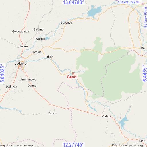
Gandi GPS coordinates[2]
12° 57' 48.888" North, 5° 44' 36.132" East
| Map corner | latitude | longitude |
|---|---|---|
| Upper-left | 13.64783°, | 5.04025° |
| Center: | 12.96358°, | 5.74337° |
| Lower-right: | 12.27745°, | 6.4465° |
| Map W x H: | 152.4×152.4 km | = 94.7×94.7mi |
| max Lat: | 13.7543° ⇑3.2% North |
| Gandi: | 12.96358° |
| min Lat: | ⇓96.8% South 4.31231° |
| min Long | Gandi | max Long |
| 2.73333° | 5.74337° | 14.46552° |
| W 26.4%⇐ | ⇒73.6% E |
Elevation
Elevation of Gandi is 278 m = 912 ft, and this is 18.5 m = 61 ft below average elevation for this country.
| Max E: |
1599 m = 5246 ft | 50.7% |
| Avg. | 296.5 m = 973 ft | |
| Gandi | 278 m = 912 ft | |
Min E: |
2 m = 7 ft | 49.3% |
See also: Nigeria elevation on elevation.city.
Geographical zone
Gandi is located in North Torrid zone (between Equator and Tropic of Cancer). Distance of this Northern Tropic circle is 1164.5 km =723.6 mi to North.| Distance of | km | miles | from Gandi |
|---|---|---|---|
| North Pole | 8565.6 | 5322.4 | to North |
| Arctic Circle | 5959.8 | 3703.2 | to North |
| Tropic Cancer | 1164.5 | 723.6 | to North |
| Equator | 1441.4 | 895.6 | to South |


Nearby cities:
15 places around Gandi: (largest is in red/bold)
• Bakura
31.4 km =19.5 mi,  153°
153°
• Bodinga
65.7 km =40.8 mi,  258°
258°
• Dange
44.8 km =27.8 mi,  254°
254°
• Goronyo
53.8 km =33.4 mi,  351°
351°
• Gwadabawa
70.1 km =43.6 mi,  308°
308°
• Isa
76.3 km =47.4 mi,  69°
69°
• Kware
59 km =36.7 mi,  298°
298°
• Maradun
69.9 km =43.4 mi,  129°
129°
• Moriki
81.3 km =50.5 mi,  97°
97°
• Rabah
31.1 km =19.3 mi, 304°
• Sokoto
55.3 km =34.4 mi,  281°
281°
• Talata Mafara
55.9 km =34.7 mi,  141°
141°
• Tureta
46.5 km =28.9 mi,  207°
207°
• Wamako
69.6 km =43.2 mi, 276°
• Wurno
50.2 km =31.2 mi,  316°
316°
Sources, notices
• [Note1] Compared only with cities in Nigeria existing in our database
• [Src1] Map data: © OpenStreetMap contributors (CC-BY-SA)
• [Src2] Other city data from geonames.org with taken over terms of usage.
• [Src3] Geographical zone / Annual Mean Temperature by Robert A. Rohde @ Wikipedia
