Ile-Oluji geodata
Ile-Oluji (Ondo) is a seat of a second-order administrative division; located in Nigeria in Africa/Lagos (GMT+1) time zone. In our database, there are 451 cities with bigger population. Compared to other cities in Nigeria, 66% of cities are located further ↑North; 83% of cities are located further →East and 56.2% of cities have higher elevation than Ile-Oluji. Note1


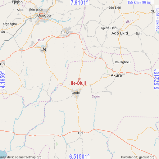
Ile-Oluji GPS coordinates[2]
7° 12' 47.124" North, 4° 52' 8.472" East
| Map corner | latitude | longitude |
|---|---|---|
| Upper-left | 7.9101°, | 4.1659° |
| Center: | 7.21309°, | 4.86902° |
| Lower-right: | 6.51501°, | 5.57215° |
| Map W x H: | 155.1×155.1 km | = 96.4×96.4mi |
| max Lat: | 13.7543° ⇑66% North |
| Ile-Oluji: | 7.21309° |
| min Lat: | ⇓34% South 4.31231° |
| min Long | Ile-Oluji | max Long |
| 2.73333° | 4.86902° | 14.46552° |
| W 17%⇐ | ⇒83% E |
Elevation
Elevation of Ile-Oluji is 240 m = 787 ft, and this is 56.5 m = 185 ft below average elevation for this country.
| Max E: |
1599 m = 5246 ft | 56.2% |
| Avg. | 296.5 m = 973 ft | |
| Ile-Oluji | 240 m = 787 ft | |
Min E: |
2 m = 7 ft | 43.8% |
See also: Nigeria elevation on elevation.city.
Geographical zone
Ile-Oluji is located in North Torrid zone (between Equator and Tropic of Cancer). Distance of Equator is 802 km =498.3 mi to South.| Distance of | km | miles | from Ile-Oluji |
|---|---|---|---|
| North Pole | 9205 | 5719.7 | to North |
| Arctic Circle | 6599.2 | 4100.6 | to North |
| Tropic Cancer | 1803.9 | 1120.9 | to North |
| Equator | 802 | 498.3 | to South |


Nearby cities:
15 places around Ile-Oluji: (largest is in red/bold)
• Akure
36 km =22.4 mi,  83°
83°
• Bolorunduro
11.7 km =7.3 mi,  116°
116°
• Idanre
29.4 km =18.3 mi,  112°
112°
• Ifetedo
18.9 km =11.7 mi,  260°
260°
• Igbara-Odo
38.6 km =24 mi,  33°
33°
• Igbara-Oke
30.4 km =18.9 mi,  43°
43°
• Iju
47.5 km =29.5 mi,  64°
64°
• Ilare
31 km =19.3 mi, 60°
• Ile-Ife
45.3 km =28.1 mi,  311°
311°
• Ilesa
48.2 km =30 mi,  343°
343°
• Iperindo
32.5 km =20.2 mi,  351°
351°
• Ita-Ogbolu
45.1 km =28 mi,  67°
67°
• Ondo
13.8 km =8.6 mi,  195°
195°
• Osu
49.5 km =30.8 mi,  326°
326°
• Owena
17.1 km =10.6 mi,  97°
97°
Sources, notices
• [Note1] Compared only with cities in Nigeria existing in our database
• [Src1] Map data: © OpenStreetMap contributors (CC-BY-SA)
• [Src2] Other city data from geonames.org with taken over terms of usage.
• [Src3] Geographical zone / Annual Mean Temperature by Robert A. Rohde @ Wikipedia
