Achalla geodata
Achalla (Anambra) is a seat of a second-order administrative division; located in Nigeria in Africa/Lagos (GMT+1) time zone. In our database, there are 451 cities with bigger population. Compared to other cities in Nigeria, 79.6% of cities are located further ↑North; 57.2% of cities are located further →East and 79.6% of cities have higher elevation than Achalla. Note1


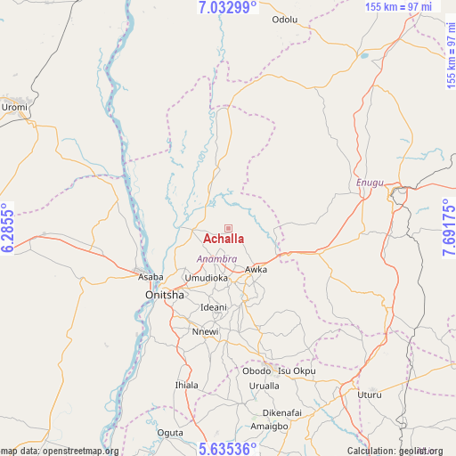
Achalla GPS coordinates[2]
6° 20' 4.74" North, 6° 59' 19.068" East
| Map corner | latitude | longitude |
|---|---|---|
| Upper-left | 7.03299°, | 6.2855° |
| Center: | 6.33465°, | 6.98863° |
| Lower-right: | 5.63536°, | 7.69175° |
| Map W x H: | 155.4×155.4 km | = 96.6×96.6mi |
| max Lat: | 13.7543° ⇑79.6% North |
| Achalla: | 6.33465° |
| min Lat: | ⇓20.4% South 4.31231° |
| min Long | Achalla | max Long |
| 2.73333° | 6.98863° | 14.46552° |
| W 42.8%⇐ | ⇒57.2% E |
Elevation
Elevation of Achalla is 84 m = 276 ft, and this is 212.5 m = 697 ft below average elevation for this country.
| Max E: |
1599 m = 5246 ft | 79.6% |
| Avg. | 296.5 m = 973 ft | |
| Achalla | 84 m = 276 ft | |
Min E: |
2 m = 7 ft | 20.4% |
See also: Nigeria elevation on elevation.city.
Geographical zone
Achalla is located in North Torrid zone (between Equator and Tropic of Cancer). Distance of Equator is 704.3 km =437.6 mi to South.| Distance of | km | miles | from Achalla |
|---|---|---|---|
| North Pole | 9302.7 | 5780.4 | to North |
| Arctic Circle | 6696.8 | 4161.2 | to North |
| Tropic Cancer | 1901.6 | 1181.6 | to North |
| Equator | 704.3 | 437.6 | to South |


Nearby cities:
15 places around Achalla: (largest is in red/bold)
• Abagana
16.1 km =10 mi,  178°
178°
• Agulu
27.2 km =16.9 mi,  162°
162°
• Aguobu-Owa
31.6 km =19.6 mi,  82°
82°
• Anaku
16.3 km =10.1 mi,  336°
336°
• Awka
16.4 km =10.2 mi,  145°
145°
• Enugu-Ukwu
18.2 km =11.3 mi,  174°
174°
• Neni
26.9 km =16.7 mi, 171°
• Nkpor
26.9 km =16.7 mi,  220°
220°
• Nteje
10.5 km =6.5 mi,  225°
225°
• Nzam
31.6 km =19.6 mi,  294°
294°
• Ogidi
24.6 km =15.3 mi,  214°
214°
• Onitsha
30.4 km =18.9 mi, 227°
• Otuocha
15.7 km =9.8 mi,  271°
271°
• Ukpo
13.6 km =8.5 mi,  190°
190°
• Umulona
22.7 km =14.1 mi,  31°
31°
Sources, notices
• [Note1] Compared only with cities in Nigeria existing in our database
• [Src1] Map data: © OpenStreetMap contributors (CC-BY-SA)
• [Src2] Other city data from geonames.org with taken over terms of usage.
• [Src3] Geographical zone / Annual Mean Temperature by Robert A. Rohde @ Wikipedia
