Umulona geodata
Umulona (Enugu) is a seat of a second-order administrative division; located in Nigeria in Africa/Lagos (GMT+1) time zone. In our database, there are 451 cities with bigger population. Compared to other cities in Nigeria, 76.5% of cities are located further ↑North; 54.4% of cities are located further →East and 82.5% of cities have higher elevation than Umulona. Note1


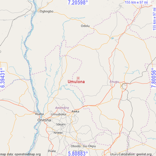
Umulona GPS coordinates[2]
6° 30' 28.404" North, 7° 5' 50.748" East
| Map corner | latitude | longitude |
|---|---|---|
| Upper-left | 7.20598°, | 6.39431° |
| Center: | 6.50789°, | 7.09743° |
| Lower-right: | 5.80883°, | 7.80056° |
| Map W x H: | 155.3×155.4 km | = 96.5×96.6mi |
| max Lat: | 13.7543° ⇑76.5% North |
| Umulona: | 6.50789° |
| min Lat: | ⇓23.5% South 4.31231° |
| min Long | Umulona | max Long |
| 2.73333° | 7.09743° | 14.46552° |
| W 45.6%⇐ | ⇒54.4% E |
Elevation
Elevation of Umulona is 71 m = 233 ft, and this is 225.5 m = 740 ft below average elevation for this country.
| Max E: |
1599 m = 5246 ft | 82.5% |
| Avg. | 296.5 m = 973 ft | |
| Umulona | 71 m = 233 ft | |
Min E: |
2 m = 7 ft | 17.5% |
See also: Nigeria elevation on elevation.city.
Geographical zone
Umulona is located in North Torrid zone (between Equator and Tropic of Cancer). Distance of Equator is 723.6 km =449.6 mi to South.| Distance of | km | miles | from Umulona |
|---|---|---|---|
| North Pole | 9283.5 | 5768.5 | to North |
| Arctic Circle | 6677.6 | 4149.3 | to North |
| Tropic Cancer | 1882.3 | 1169.6 | to North |
| Equator | 723.6 | 449.6 | to South |


Nearby cities:
15 places around Umulona: (largest is in red/bold)
• Abagana
37.1 km =23.1 mi,  198°
198°
• Achalla
22.7 km =14.1 mi,  211°
211°
• Adani
27.5 km =17.1 mi,  339°
339°
• Aguobu-Owa
24.5 km =15.2 mi,  128°
128°
• Aku
33.1 km =20.6 mi,  47°
47°
• Anaku
19.1 km =11.9 mi,  256°
256°
• Awka
32.9 km =20.4 mi,  184°
184°
• Enugu-Ukwu
38.8 km =24.1 mi, 195°
• Nteje
33.1 km =20.6 mi,  216°
216°
• Nzam
41.2 km =25.6 mi, 261°
• Ogbede
35.7 km =22.2 mi,  59°
59°
• Ogurugu
35 km =21.7 mi,  332°
332°
• Oji River
33.9 km =21.1 mi,  145°
145°
• Otuocha
33.5 km =20.8 mi,  235°
235°
• Ukpo
35.7 km =22.2 mi, 203°
Sources, notices
• [Note1] Compared only with cities in Nigeria existing in our database
• [Src1] Map data: © OpenStreetMap contributors (CC-BY-SA)
• [Src2] Other city data from geonames.org with taken over terms of usage.
• [Src3] Geographical zone / Annual Mean Temperature by Robert A. Rohde @ Wikipedia
