Agulu geodata
Agulu (Anambra) is a populated place; located in Nigeria in Africa/Lagos (GMT+1) time zone. With population of 79,021 people, there are 115 cities with bigger population in this country. Compared to other cities in Nigeria, 82.4% of cities are located further ↑North; 55.4% of cities are located further →East and 60.9% of cities have higher elevation than Agulu. Note1


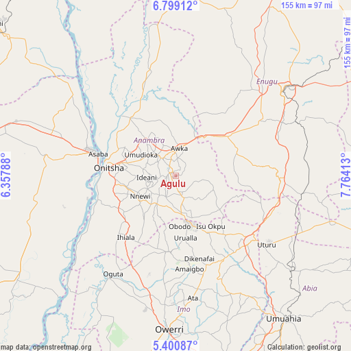
Agulu GPS coordinates[2]
6° 6' 1.62" North, 7° 3' 39.6" East
| Map corner | latitude | longitude |
|---|---|---|
| Upper-left | 6.79912°, | 6.35788° |
| Center: | 6.10045°, | 7.061° |
| Lower-right: | 5.40087°, | 7.76413° |
| Map W x H: | 155.5×155.5 km | = 96.6×96.6mi |
| max Lat: | 13.7543° ⇑82.4% North |
| Agulu: | 6.10045° |
| min Lat: | ⇓17.6% South 4.31231° |
| min Long | Agulu | max Long |
| 2.73333° | 7.061° | 14.46552° |
| W 44.6%⇐ | ⇒55.4% E |
Elevation
Elevation of Agulu is 201 m = 659 ft, and this is 95.5 m = 313 ft below average elevation for this country.
| Max E: |
1599 m = 5246 ft | 60.9% |
| Avg. | 296.5 m = 973 ft | |
| Agulu | 201 m = 659 ft | |
Min E: |
2 m = 7 ft | 39.1% |
See also: Agulu elevation on elevation.city.
Geographical zone
Agulu is located in North Torrid zone (between Equator and Tropic of Cancer). Distance of Equator is 678.3 km =421.5 mi to South.| Distance of | km | miles | from Agulu |
|---|---|---|---|
| North Pole | 9328.8 | 5796.6 | to North |
| Arctic Circle | 6722.9 | 4177.4 | to North |
| Tropic Cancer | 1927.6 | 1197.8 | to North |
| Equator | 678.3 | 421.5 | to South |


Nearby cities:
15 places around Agulu: (largest is in red/bold)
• Abagana
12.5 km =7.8 mi,  323°
323°
• Aguata
9.8 km =6.1 mi,  162°
162°
• Ajalli
17.5 km =10.9 mi,  110°
110°
• Awka
12.5 km =7.8 mi,  5°
5°
• Enugu-Ukwu
10 km =6.2 mi, 322°
• Igbo-Ukwu
10.2 km =6.3 mi,  206°
206°
• Neni
4.1 km =2.5 mi,  261°
261°
• Nnewi
18.3 km =11.4 mi,  240°
240°
• Nteje
24.3 km =15.1 mi, 320°
• Ogidi
22.6 km =14 mi,  284°
284°
• Ojoto
22.6 km =14 mi, 258°
• Uga
18.4 km =11.4 mi,  173°
173°
• Ukpo
16.4 km =10.2 mi, 320°
• Ukpor
22.8 km =14.2 mi,  219°
219°
• Umunze
24.4 km =15.2 mi,  127°
127°
Sources, notices
• [Note1] Compared only with cities in Nigeria existing in our database
• [Src1] Map data: © OpenStreetMap contributors (CC-BY-SA)
• [Src2] Other city data from geonames.org with taken over terms of usage.
• [Src3] Geographical zone / Annual Mean Temperature by Robert A. Rohde @ Wikipedia
