Suleja geodata
Suleja (Niger) is a seat of a second-order administrative division; located in Nigeria in Africa/Lagos (GMT+1) time zone. With population of 162,135 people, there are 54 cities with bigger population in this country. Compared to other cities in Nigeria, 56.5% of cities are located further ↓South; 52.8% of cities are located further →East and 73.8% of cities have lower elevation than Suleja. Note1


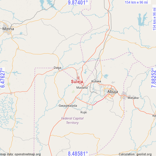
Suleja GPS coordinates[2]
9° 10' 50.124" North, 7° 10' 45.804" East
| Map corner | latitude | longitude |
|---|---|---|
| Upper-left | 9.87401°, | 6.47627° |
| Center: | 9.18059°, | 7.17939° |
| Lower-right: | 8.48581°, | 7.88252° |
| Map W x H: | 154.4×154.4 km | = 95.9×95.9mi |
| max Lat: | 13.7543° ⇑43.5% North |
| Suleja: | 9.18059° |
| min Lat: | ⇓56.5% South 4.31231° |
| min Long | Suleja | max Long |
| 2.73333° | 7.17939° | 14.46552° |
| W 47.2%⇐ | ⇒52.8% E |
Elevation
Elevation of Suleja is 421 m = 1381 ft, and this is 124.5 m = 408 ft above average elevation for this country.
| Max E: |
1599 m = 5246 ft | 26.2% |
| Suleja | 421 m 1381 ft | |
| Avg. | 296.5 m = 973 ft | |
Min E: |
2 m = 7 ft | 73.8% |
See also: Suleja elevation on elevation.city.
Geographical zone
Suleja is located in North Torrid zone (between Equator and Tropic of Cancer). Distance of Equator is 1020.8 km =634.3 mi to South.| Distance of | km | miles | from Suleja |
|---|---|---|---|
| North Pole | 8986.3 | 5583.8 | to North |
| Arctic Circle | 6380.4 | 3964.6 | to North |
| Tropic Cancer | 1585.1 | 984.9 | to North |
| Equator | 1020.8 | 634.3 | to South |


Nearby cities:
15 places around Suleja: (largest is in red/bold)
• Abaji
82.7 km =51.4 mi,  198°
198°
• Abuja
37.2 km =23.1 mi,  111°
111°
• Buga
78.8 km =49 mi,  166°
166°
• Bwari
24.7 km =15.3 mi,  63°
63°
• Gawu Babangida
23.1 km =14.4 mi,  298°
298°
• Gwagwalada
28.5 km =17.7 mi, 202°
• Kagarko
66.5 km =41.3 mi, 58°
• Karu
56.2 km =34.9 mi, 109°
• Kuje
33.9 km =21.1 mi, 171°
• Kwali
37.5 km =23.3 mi,  208°
208°
• Lapai
68.5 km =42.6 mi,  257°
257°
• Madala
9.3 km =5.8 mi,  156°
156°
• Minna
84.5 km =52.5 mi, 304°
• Paiko
66.3 km =41.2 mi, 295°
• Sabon Wuse
19.3 km =12 mi,  27°
27°
Sources, notices
• [Note1] Compared only with cities in Nigeria existing in our database
• [Src1] Map data: © OpenStreetMap contributors (CC-BY-SA)
• [Src2] Other city data from geonames.org with taken over terms of usage.
• [Src3] Geographical zone / Annual Mean Temperature by Robert A. Rohde @ Wikipedia
