Siuna geodata
Siuna (North Caribbean Coast) is a seat of a second-order administrative division; located in Nicaragua in America/Managua (GMT-6) time zone. With population of 16,056 people, there are 34 cities with bigger population in this country. Compared to other cities in Nicaragua, 95.8% of cities are located further ↓South; 88.6% of cities are located further ←West and 55.1% of cities have higher elevation than Siuna. Note1


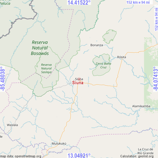
Siuna GPS coordinates[2]
13° 43' 59.556" North, 84° 46' 38.1" West
| Map corner | latitude | longitude |
|---|---|---|
| Upper-left | 14.41522°, | -85.48038° |
| Center: | 13.73321°, | -84.77725° |
| Lower-right: | 13.04921°, | -84.07413° |
| Map W x H: | 151.9×151.9 km | = 94.4×94.4mi |
| max Lat: | 14.74189° ⇑4.2% North |
| Siuna: | 13.73321° |
| min Lat: | ⇓95.8% South 10.94684° |
| min Long | Siuna | max Long |
| -87.4516° | -84.77725° | -83.06145° |
| W 88.6%⇐ | ⇒11.4% E |
Elevation
Elevation of Siuna is 193 m = 633 ft, and this is 144.2 m = 473 ft below average elevation for this country.
| Max E: |
1288 m = 4226 ft | 55.1% |
| Avg. | 337.2 m = 1106 ft | |
| Siuna | 193 m = 633 ft | |
Min E: |
1 m = 3 ft | 44.9% |
See also: Nicaragua elevation on elevation.city.
Geographical zone
Siuna is located in North Torrid zone (between Equator and Tropic of Cancer). Distance of this Northern Tropic circle is 1078.9 km =670.4 mi to North.| Distance of | km | miles | from Siuna |
|---|---|---|---|
| North Pole | 8480.1 | 5269.3 | to North |
| Arctic Circle | 5874.2 | 3650.1 | to North |
| Tropic Cancer | 1078.9 | 670.4 | to North |
| Equator | 1527 | 948.8 | to South |


Nearby cities:
15 places around Siuna: (largest is in red/bold)
• Bocana de Paiwas
111.8 km =69.5 mi,  199°
199°
• Bocay
74.6 km =46.4 mi,  327°
327°
• Bonanza
38.5 km =23.9 mi,  31°
31°
• El Cuá
105 km =65.2 mi,  247°
247°
• El Cuá
110.9 km =68.9 mi, 251°
• La Cruz de Río Grande
94.1 km =58.5 mi,  137°
137°
• Mulukukú
64.9 km =40.3 mi, 197°
• Rancho Grande
100.9 km =62.7 mi,  236°
236°
• Río Blanco
101.1 km =62.8 mi,  208°
208°
• San José de Bocay
85.1 km =52.9 mi,  255°
255°
• Waslala
77.9 km =48.4 mi, 235°
• Waslala
85.9 km =53.4 mi,  229°
229°
• Wiwili
113.9 km =70.8 mi, 263°
• Wiwilí
113.9 km =70.8 mi, 264°
• Wiwilí de Jinotega
113.1 km =70.3 mi, 263°
Sources, notices
• [Note1] Compared only with cities in Nicaragua existing in our database
• [Src1] Map data: © OpenStreetMap contributors (CC-BY-SA)
• [Src2] Other city data from geonames.org with taken over terms of usage.
• [Src3] Geographical zone / Annual Mean Temperature by Robert A. Rohde @ Wikipedia
