Bocay geodata
Bocay (Jinotega) is a seat of a second-order administrative division; located in Nicaragua in America/Managua (GMT-6) time zone. In our database, there are 137 cities with bigger population. Compared to other cities in Nicaragua, 99.4% of cities are located further ↓South; 82% of cities are located further ←West and 59.3% of cities have higher elevation than Bocay. Note1


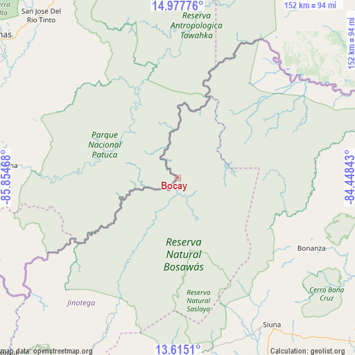
Bocay GPS coordinates[2]
14° 17' 50.856" North, 85° 9' 5.58" West
| Map corner | latitude | longitude |
|---|---|---|
| Upper-left | 14.97776°, | -85.85468° |
| Center: | 14.29746°, | -85.15155° |
| Lower-right: | 13.6151°, | -84.44843° |
| Map W x H: | 151.5×151.5 km | = 94.1×94.1mi |
| max Lat: | 14.74189° ⇑0.6% North |
| Bocay: | 14.29746° |
| min Lat: | ⇓99.4% South 10.94684° |
| min Long | Bocay | max Long |
| -87.4516° | -85.15155° | -83.06145° |
| W 82%⇐ | ⇒18% E |
Elevation
Elevation of Bocay is 166 m = 545 ft, and this is 171.2 m = 562 ft below average elevation for this country.
| Max E: |
1288 m = 4226 ft | 59.3% |
| Avg. | 337.2 m = 1106 ft | |
| Bocay | 166 m = 545 ft | |
Min E: |
1 m = 3 ft | 40.7% |
See also: Nicaragua elevation on elevation.city.
Geographical zone
Bocay is located in North Torrid zone (between Equator and Tropic of Cancer). Distance of this Northern Tropic circle is 1016.2 km =631.4 mi to North.| Distance of | km | miles | from Bocay |
|---|---|---|---|
| North Pole | 8417.3 | 5230.3 | to North |
| Arctic Circle | 5811.4 | 3611 | to North |
| Tropic Cancer | 1016.2 | 631.4 | to North |
| Equator | 1589.7 | 987.8 | to South |


Nearby cities:
15 places around Bocay: (largest is in red/bold)
• Bonanza
67.4 km =41.9 mi,  116°
116°
• El Cuá
117.3 km =72.9 mi,  213°
213°
• El Cuá
117.7 km =73.1 mi, 208°
• El Jícaro
124.2 km =77.2 mi,  239°
239°
• Jalapa
112.8 km =70.1 mi,  248°
248°
• Murra
111.1 km =69 mi, 237°
• Quilalí
124.5 km =77.4 mi,  229°
229°
• Rancho Grande
125.8 km =78.2 mi,  200°
200°
• San José de Bocay
93.8 km =58.3 mi, 206°
• Siuna
74.6 km =46.4 mi,  147°
147°
• Waslala
109.5 km =68 mi,  192°
192°
• Waslala
120.9 km =75.1 mi, 191°
• Wiwili
104.8 km =65.1 mi,  223°
223°
• Wiwilí
104.2 km =64.7 mi, 224°
• Wiwilí de Jinotega
104.5 km =64.9 mi, 223°
Sources, notices
• [Note1] Compared only with cities in Nicaragua existing in our database
• [Src1] Map data: © OpenStreetMap contributors (CC-BY-SA)
• [Src2] Other city data from geonames.org with taken over terms of usage.
• [Src3] Geographical zone / Annual Mean Temperature by Robert A. Rohde @ Wikipedia
