Nandaime geodata
Nandaime (Granada) is a seat of a second-order administrative division; located in Nicaragua in America/Managua (GMT-6) time zone. With population of 20,810 people, there are 27 cities with bigger population in this country. Compared to other cities in Nicaragua, 88% of cities are located further ↑North; 52.1% of cities are located further ←West and 61.1% of cities have higher elevation than Nandaime. Note1


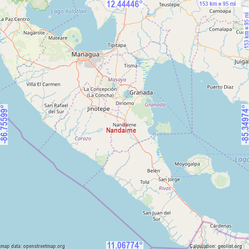
Nandaime GPS coordinates[2]
11° 45' 25.056" North, 86° 3' 10.296" West
| Map corner | latitude | longitude |
|---|---|---|
| Upper-left | 12.44446°, | -86.75599° |
| Center: | 11.75696°, | -86.05286° |
| Lower-right: | 11.06774°, | -85.34974° |
| Map W x H: | 153.1×153.1 km | = 95.1×95.1mi |
| max Lat: | 14.74189° ⇑88% North |
| Nandaime: | 11.75696° |
| min Lat: | ⇓12% South 10.94684° |
| min Long | Nandaime | max Long |
| -87.4516° | -86.05286° | -83.06145° |
| W 52.1%⇐ | ⇒47.9% E |
Elevation
Elevation of Nandaime is 142 m = 466 ft, and this is 195.2 m = 640 ft below average elevation for this country.
| Max E: |
1288 m = 4226 ft | 61.1% |
| Avg. | 337.2 m = 1106 ft | |
| Nandaime | 142 m = 466 ft | |
Min E: |
1 m = 3 ft | 38.9% |
See also: Nicaragua elevation on elevation.city.
Geographical zone
Nandaime is located in North Torrid zone (between Equator and Tropic of Cancer). Distance of this Northern Tropic circle is 1298.7 km =807 mi to North.| Distance of | km | miles | from Nandaime |
|---|---|---|---|
| North Pole | 8699.8 | 5405.8 | to North |
| Arctic Circle | 6093.9 | 3786.6 | to North |
| Tropic Cancer | 1298.7 | 807 | to North |
| Equator | 1307.3 | 812.3 | to South |


Nearby cities:
15 places around Nandaime: (largest is in red/bold)
• Catarina
17.4 km =10.8 mi,  352°
352°
• Diriomo
13.3 km =8.3 mi,  0°
0°
• Diriá
14.1 km =8.8 mi,  359°
359°
• Dolores
20.9 km =13 mi,  302°
302°
• El Rosario
14.9 km =9.3 mi, 304°
• Granada
21.9 km =13.6 mi,  28°
28°
• Jinotepe
19 km =11.8 mi, 302°
• La Conquista
15.4 km =9.6 mi,  260°
260°
• La Paz de Carazo
11 km =6.8 mi,  312°
312°
• Masatepe
20.2 km =12.6 mi,  330°
330°
• Nandasmo
20 km =12.4 mi,  338°
338°
• Niquinohomo
17.1 km =10.6 mi, 344°
• San Juan de Oriente
16.7 km =10.4 mi, 352°
• Santa Teresa
13 km =8.1 mi,  293°
293°
• Santa Teresa
17.6 km =10.9 mi,  265°
265°
Sources, notices
• [Note1] Compared only with cities in Nicaragua existing in our database
• [Src1] Map data: © OpenStreetMap contributors (CC-BY-SA)
• [Src2] Other city data from geonames.org with taken over terms of usage.
• [Src3] Geographical zone / Annual Mean Temperature by Robert A. Rohde @ Wikipedia
