Managua geodata
Managua is a capital of a political entity; located in Nicaragua in America/Managua (GMT-6) time zone. With population of 973,087 people, there are 0 cities with bigger population in this country. Compared to other cities in Nicaragua, 67.7% of cities are located further ↑North; 66.5% of cities are located further →East and 67.7% of cities have higher elevation than Managua. Note1


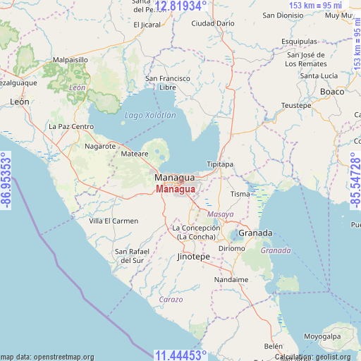
Managua GPS coordinates[2]
12° 7' 58.152" North, 86° 15' 1.44" West
| Map corner | latitude | longitude |
|---|---|---|
| Upper-left | 12.81934°, | -86.95353° |
| Center: | 12.13282°, | -86.2504° |
| Lower-right: | 11.44453°, | -85.54728° |
| Map W x H: | 152.9×152.9 km | = 95×95mi |
| max Lat: | 14.74189° ⇑67.7% North |
| Managua: | 12.13282° |
| min Lat: | ⇓32.3% South 10.94684° |
| min Long | Managua | max Long |
| -87.4516° | -86.2504° | -83.06145° |
| W 33.5%⇐ | ⇒66.5% E |
Elevation
Elevation of Managua is 108 m = 354 ft, and this is 229.2 m = 752 ft below average elevation for this country.
| Max E: |
1288 m = 4226 ft | 67.7% |
| Avg. | 337.2 m = 1106 ft | |
| Managua | 108 m = 354 ft | |
Min E: |
1 m = 3 ft | 32.3% |
See also: Managua elevation on elevation.city.
Geographical zone
Managua is located in North Torrid zone (between Equator and Tropic of Cancer). Distance of this Northern Tropic circle is 1256.9 km =781 mi to North.| Distance of | km | miles | from Managua |
|---|---|---|---|
| North Pole | 8658 | 5379.8 | to North |
| Arctic Circle | 6052.1 | 3760.6 | to North |
| Tropic Cancer | 1256.9 | 781 | to North |
| Equator | 1349 | 838.2 | to South |


Nearby cities:
15 places around Managua: (largest is in red/bold)
• Ciudad Sandino
10.6 km =6.6 mi,  285°
285°
• Diriamba
30.6 km =19 mi,  177°
177°
• Dolores
30.9 km =19.2 mi,  172°
172°
• El Crucero
17.1 km =10.6 mi,  202°
202°
• La Concepción
22.7 km =14.1 mi,  163°
163°
• Masatepe
26.9 km =16.7 mi,  154°
154°
• Masaya
24.5 km =15.2 mi,  136°
136°
• Mateare
22.4 km =13.9 mi,  300°
300°
• Nandasmo
27.2 km =16.9 mi, 148°
• Nindirí
20.1 km =12.5 mi, 135°
• Niquinohomo
30.5 km =19 mi, 146°
• San Marcos
25.4 km =15.8 mi, 168°
• Ticuantepe
13.2 km =8.2 mi, 158°
• Tipitapa
18.1 km =11.2 mi,  66°
66°
• Tisma
26 km =16.2 mi,  102°
102°
Sources, notices
• [Note1] Compared only with cities in Nicaragua existing in our database
• [Src1] Map data: © OpenStreetMap contributors (CC-BY-SA)
• [Src2] Other city data from geonames.org with taken over terms of usage.
• [Src3] Geographical zone / Annual Mean Temperature by Robert A. Rohde @ Wikipedia
