El Crucero geodata
El Crucero (Managua) is a seat of a second-order administrative division; located in Nicaragua in America/Managua (GMT-6) time zone. With population of 16,469 people, there are 33 cities with bigger population in this country. Compared to other cities in Nicaragua, 73.7% of cities are located further ↑North; 69.5% of cities are located further →East and 95.8% of cities have lower elevation than El Crucero. Note1


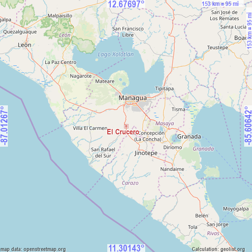
El Crucero GPS coordinates[2]
11° 59' 24.288" North, 86° 18' 34.344" West
| Map corner | latitude | longitude |
|---|---|---|
| Upper-left | 12.67697°, | -87.01267° |
| Center: | 11.99008°, | -86.30954° |
| Lower-right: | 11.30143°, | -85.60642° |
| Map W x H: | 152.9×152.9 km | = 95×95mi |
| max Lat: | 14.74189° ⇑73.7% North |
| El Crucero: | 11.99008° |
| min Lat: | ⇓26.3% South 10.94684° |
| min Long | El Crucero | max Long |
| -87.4516° | -86.30954° | -83.06145° |
| W 30.5%⇐ | ⇒69.5% E |
Elevation
Elevation of El Crucero is 930 m = 3051 ft, and this is 592.8 m = 1945 ft above average elevation for this country.
| Max E: |
1288 m = 4226 ft | 4.2% |
| El Crucero | 930 m 3051 ft | |
| Avg. | 337.2 m = 1106 ft | |
Min E: |
1 m = 3 ft | 95.8% |
See also: Nicaragua elevation on elevation.city.
Geographical zone
El Crucero is located in North Torrid zone (between Equator and Tropic of Cancer). Distance of this Northern Tropic circle is 1272.7 km =790.8 mi to North.| Distance of | km | miles | from El Crucero |
|---|---|---|---|
| North Pole | 8673.9 | 5389.7 | to North |
| Arctic Circle | 6068 | 3770.5 | to North |
| Tropic Cancer | 1272.7 | 790.8 | to North |
| Equator | 1333.2 | 828.4 | to South |


Nearby cities:
15 places around El Crucero: (largest is in red/bold)
• Ciudad Sandino
19.1 km =11.9 mi,  348°
348°
• Diriamba
16.5 km =10.3 mi,  152°
152°
• Dolores
18 km =11.2 mi, 145°
• El Rosario
23.5 km =14.6 mi,  138°
138°
• Jinotepe
19.7 km =12.2 mi, 142°
• La Concepción
14.3 km =8.9 mi,  114°
114°
• Managua
17.1 km =10.6 mi,  22°
22°
• Masatepe
19.8 km =12.3 mi,  115°
115°
• Masaya
23.5 km =14.6 mi,  94°
94°
• Nandasmo
21.8 km =13.5 mi, 109°
• Nindirí
20.5 km =12.7 mi, 85°
• San Marcos
14.6 km =9.1 mi,  127°
127°
• San Rafael del Sur
21.1 km =13.1 mi,  221°
221°
• Ticuantepe
11.9 km =7.4 mi,  72°
72°
• Villa El Carmen
21.4 km =13.3 mi,  267°
267°
Sources, notices
• [Note1] Compared only with cities in Nicaragua existing in our database
• [Src1] Map data: © OpenStreetMap contributors (CC-BY-SA)
• [Src2] Other city data from geonames.org with taken over terms of usage.
• [Src3] Geographical zone / Annual Mean Temperature by Robert A. Rohde @ Wikipedia
