Jiquilillo geodata
Jiquilillo (Chinandega) is a populated place; located in Nicaragua in America/Managua (GMT-6) time zone. With population of 4,142 people, there are 83 cities with bigger population in this country. Compared to other cities in Nicaragua, 55.7% of cities are located further ↓South; 100% of cities are located further →East and 97.6% of cities have higher elevation than Jiquilillo. Note1


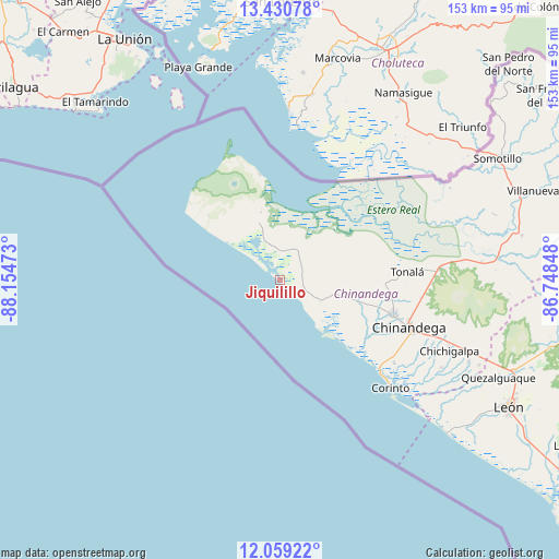
Jiquilillo GPS coordinates[2]
12° 44' 45.348" North, 87° 27' 5.76" West
| Map corner | latitude | longitude |
|---|---|---|
| Upper-left | 13.43078°, | -88.15473° |
| Center: | 12.74593°, | -87.4516° |
| Lower-right: | 12.05922°, | -86.74848° |
| Map W x H: | 152.5×152.5 km | = 94.8×94.8mi |
| max Lat: | 14.74189° ⇑44.3% North |
| Jiquilillo: | 12.74593° |
| min Lat: | ⇓55.7% South 10.94684° |
| min Long | Jiquilillo | max Long |
| -87.4516° | -87.4516° | -83.06145° |
| W 0%⇐ | ⇒100% E |
Elevation
Elevation of Jiquilillo is 9 m = 30 ft, and this is 328.2 m = 1077 ft below average elevation for this country.
| Max E: |
1288 m = 4226 ft | 97.6% |
| Avg. | 337.2 m = 1106 ft | |
| Jiquilillo | 9 m = 30 ft | |
Min E: |
1 m = 3 ft | 2.4% |
See also: Nicaragua elevation on elevation.city.
Geographical zone
Jiquilillo is located in North Torrid zone (between Equator and Tropic of Cancer). Distance of this Northern Tropic circle is 1188.7 km =738.6 mi to North.| Distance of | km | miles | from Jiquilillo |
|---|---|---|---|
| North Pole | 8589.8 | 5337.5 | to North |
| Arctic Circle | 5984 | 3718.3 | to North |
| Tropic Cancer | 1188.7 | 738.6 | to North |
| Equator | 1417.2 | 880.6 | to South |


Nearby cities:
15 places around Jiquilillo: (largest is in red/bold)
• Chichigalpa
49.7 km =30.9 mi,  112°
112°
• Chinandega
37.1 km =23.1 mi, 110°
• Corinto
42.1 km =26.2 mi,  134°
134°
• El Realejo
38.4 km =23.9 mi, 125°
• El Viejo
32.2 km =20 mi, 106°
• León
71 km =44.1 mi,  118°
118°
• Posoltega
55.9 km =34.7 mi, 113°
• Puerto Morazán
32.5 km =20.2 mi,  69°
69°
• Quezalguaque
65.2 km =40.5 mi, 114°
• San Francisco
8.9 km =5.5 mi,  4°
4°
• Santo Tomás del Norte
75.4 km =46.9 mi,  49°
49°
• Somotillo
67.9 km =42.2 mi,  60°
60°
• Telica
68.9 km =42.8 mi, 111°
• Tonalá
34.6 km =21.5 mi,  86°
86°
• Villanueva
73.1 km =45.4 mi, 70°
Sources, notices
• [Note1] Compared only with cities in Nicaragua existing in our database
• [Src1] Map data: © OpenStreetMap contributors (CC-BY-SA)
• [Src2] Other city data from geonames.org with taken over terms of usage.
• [Src3] Geographical zone / Annual Mean Temperature by Robert A. Rohde @ Wikipedia
