León geodata
León is a seat of a first-order administrative division; located in Nicaragua in America/Managua (GMT-6) time zone. With population of 144,538 people, there is 1 city with bigger population in this country. Compared to other cities in Nicaragua, 56.9% of cities are located further ↑North; 92.2% of cities are located further →East and 68.9% of cities have higher elevation than León. Note1


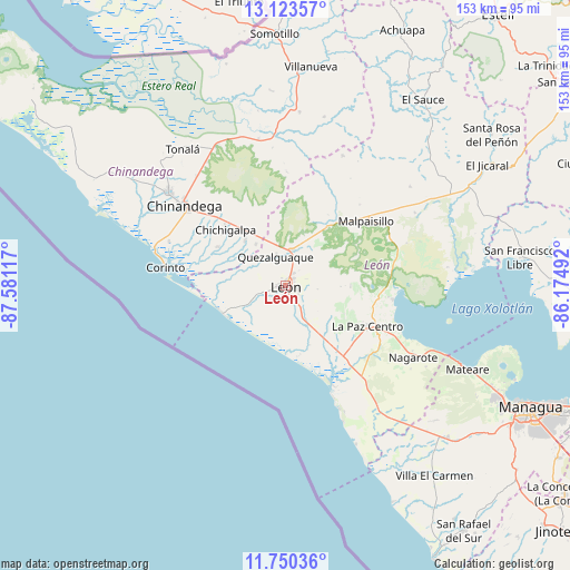
León GPS coordinates[2]
12° 26' 16.332" North, 86° 52' 40.944" West
| Map corner | latitude | longitude |
|---|---|---|
| Upper-left | 13.12357°, | -87.58117° |
| Center: | 12.43787°, | -86.87804° |
| Lower-right: | 11.75036°, | -86.17492° |
| Map W x H: | 152.7×152.7 km | = 94.9×94.9mi |
| max Lat: | 14.74189° ⇑56.9% North |
| León: | 12.43787° |
| min Lat: | ⇓43.1% South 10.94684° |
| min Long | León | max Long |
| -87.4516° | -86.87804° | -83.06145° |
| W 7.8%⇐ | ⇒92.2% E |
Elevation
Elevation of León is 107 m = 351 ft, and this is 230.2 m = 755 ft below average elevation for this country.
| Max E: |
1288 m = 4226 ft | 68.9% |
| Avg. | 337.2 m = 1106 ft | |
| León | 107 m = 351 ft | |
Min E: |
1 m = 3 ft | 31.1% |
See also: León elevation on elevation.city.
Geographical zone
León is located in North Torrid zone (between Equator and Tropic of Cancer). Distance of this Northern Tropic circle is 1223 km =759.9 mi to North.| Distance of | km | miles | from León |
|---|---|---|---|
| North Pole | 8624.1 | 5358.8 | to North |
| Arctic Circle | 6018.2 | 3739.5 | to North |
| Tropic Cancer | 1223 | 759.9 | to North |
| Equator | 1383 | 859.4 | to South |


Nearby cities:
15 places around León: (largest is in red/bold)
• Chichigalpa
22.4 km =13.9 mi,  313°
313°
• Chinandega
34.7 km =21.6 mi, 307°
• Corinto
32.4 km =20.1 mi,  278°
278°
• El Realejo
33.3 km =20.7 mi,  290°
290°
• El Viejo
40.1 km =24.9 mi, 308°
• La Paz Centro
24.6 km =15.3 mi,  116°
116°
• Larreynaga
42.5 km =26.4 mi,  51°
51°
• Malpaisillo
27.7 km =17.2 mi, 51°
• Mateare
53.8 km =33.4 mi,  114°
114°
• Nagarote
39 km =24.2 mi, 119°
• Posoltega
16.2 km =10.1 mi,  316°
316°
• Puerto Morazán
55.8 km =34.7 mi,  325°
325°
• Quezalguaque
8.1 km =5 mi,  340°
340°
• Telica
9.6 km =6 mi,  12°
12°
• Tonalá
45.9 km =28.5 mi, 322°
Sources, notices
• [Note1] Compared only with cities in Nicaragua existing in our database
• [Src1] Map data: © OpenStreetMap contributors (CC-BY-SA)
• [Src2] Other city data from geonames.org with taken over terms of usage.
• [Src3] Geographical zone / Annual Mean Temperature by Robert A. Rohde @ Wikipedia
