Somotillo geodata
Somotillo (Chinandega) is a seat of a second-order administrative division; located in Nicaragua in America/Managua (GMT-6) time zone. With population of 15,385 people, there are 35 cities with bigger population in this country. Compared to other cities in Nicaragua, 67.7% of cities are located further ↓South; 93.4% of cities are located further →East and 87.4% of cities have higher elevation than Somotillo. Note1


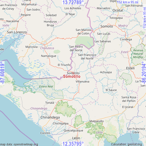
Somotillo GPS coordinates[2]
13° 2' 37.932" North, 86° 54' 18.216" West
| Map corner | latitude | longitude |
|---|---|---|
| Upper-left | 13.72789°, | -87.60819° |
| Center: | 13.04387°, | -86.90506° |
| Lower-right: | 12.35795°, | -86.20194° |
| Map W x H: | 152.3×152.3 km | = 94.6×94.6mi |
| max Lat: | 14.74189° ⇑32.3% North |
| Somotillo: | 13.04387° |
| min Lat: | ⇓67.7% South 10.94684° |
| min Long | Somotillo | max Long |
| -87.4516° | -86.90506° | -83.06145° |
| W 6.6%⇐ | ⇒93.4% E |
Elevation
Elevation of Somotillo is 46 m = 151 ft, and this is 291.2 m = 955 ft below average elevation for this country.
| Max E: |
1288 m = 4226 ft | 87.4% |
| Avg. | 337.2 m = 1106 ft | |
| Somotillo | 46 m = 151 ft | |
Min E: |
1 m = 3 ft | 12.6% |
See also: Nicaragua elevation on elevation.city.
Geographical zone
Somotillo is located in North Torrid zone (between Equator and Tropic of Cancer). Distance of this Northern Tropic circle is 1155.6 km =718.1 mi to North.| Distance of | km | miles | from Somotillo |
|---|---|---|---|
| North Pole | 8556.7 | 5316.9 | to North |
| Arctic Circle | 5950.8 | 3697.7 | to North |
| Tropic Cancer | 1155.6 | 718.1 | to North |
| Equator | 1450.3 | 901.2 | to South |


Nearby cities:
15 places around Somotillo: (largest is in red/bold)
• Achuapa
34.1 km =21.2 mi,  88°
88°
• Chinandega
52.2 km =32.4 mi,  207°
207°
• Cinco Pinos
21 km =13 mi,  10°
10°
• El Sauce
43.3 km =26.9 mi,  113°
113°
• El Viejo
50.9 km =31.6 mi, 213°
• Las Sabanas
45.2 km =28.1 mi,  42°
42°
• Puerto Morazán
36 km =22.4 mi,  233°
233°
• San Francisco del Norte
22.6 km =14 mi, 40°
• San José de Cusmapa
38.3 km =23.8 mi, 44°
• San Juan de Limay
34.9 km =21.7 mi,  65°
65°
• San Lucas
52 km =32.3 mi, 37°
• San Pedro del Norte
26 km =16.2 mi, 6°
• Santo Tomás del Norte
15.9 km =9.9 mi,  353°
353°
• Tonalá
39.5 km =24.5 mi,  218°
218°
• Villanueva
13.2 km =8.2 mi,  132°
132°
Sources, notices
• [Note1] Compared only with cities in Nicaragua existing in our database
• [Src1] Map data: © OpenStreetMap contributors (CC-BY-SA)
• [Src2] Other city data from geonames.org with taken over terms of usage.
• [Src3] Geographical zone / Annual Mean Temperature by Robert A. Rohde @ Wikipedia
