El Ayote geodata
El Ayote (Chontales) is a populated place; located in Nicaragua in America/Managua (GMT-6) time zone. With population of 5,406 people, there are 72 cities with bigger population in this country. Compared to other cities in Nicaragua, 65.3% of cities are located further ↑North; 79.6% of cities are located further ←West and 72.5% of cities have lower elevation than El Ayote. Note1


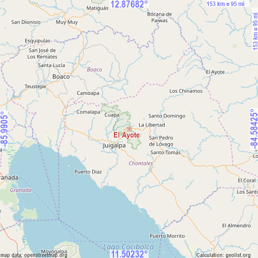
El Ayote GPS coordinates[2]
12° 11' 25.656" North, 85° 17' 14.532" West
| Map corner | latitude | longitude |
|---|---|---|
| Upper-left | 12.87682°, | -85.9905° |
| Center: | 12.19046°, | -85.28737° |
| Lower-right: | 11.50232°, | -84.58425° |
| Map W x H: | 152.8×152.8 km | = 94.9×94.9mi |
| max Lat: | 14.74189° ⇑65.3% North |
| El Ayote: | 12.19046° |
| min Lat: | ⇓34.7% South 10.94684° |
| min Long | El Ayote | max Long |
| -87.4516° | -85.28737° | -83.06145° |
| W 79.6%⇐ | ⇒20.4% E |
Elevation
Elevation of El Ayote is 504 m = 1654 ft, and this is 166.8 m = 547 ft above average elevation for this country.
| Max E: |
1288 m = 4226 ft | 27.5% |
| El Ayote | 504 m 1654 ft | |
| Avg. | 337.2 m = 1106 ft | |
Min E: |
1 m = 3 ft | 72.5% |
See also: Nicaragua elevation on elevation.city.
Geographical zone
El Ayote is located in North Torrid zone (between Equator and Tropic of Cancer). Distance of this Northern Tropic circle is 1250.5 km =777 mi to North.| Distance of | km | miles | from El Ayote |
|---|---|---|---|
| North Pole | 8651.6 | 5375.9 | to North |
| Arctic Circle | 6045.7 | 3756.6 | to North |
| Tropic Cancer | 1250.5 | 777 | to North |
| Equator | 1355.5 | 842.3 | to South |


Nearby cities:
15 places around El Ayote: (largest is in red/bold)
• Acoyapa
27.6 km =17.1 mi,  152°
152°
• Boaco
51.1 km =31.8 mi,  307°
307°
• Camoapa
32.6 km =20.3 mi, 311°
• Comalapa
26.4 km =16.4 mi,  293°
293°
• Cuapa
13.5 km =8.4 mi, 310°
• El Ayote
61.7 km =38.3 mi,  56°
56°
• Juigalpa
12.6 km =7.8 mi,  221°
221°
• La Libertad
13.5 km =8.4 mi,  77°
77°
• San Lorenzo
46.2 km =28.7 mi,  296°
296°
• San Pedro de Lóvago
19.9 km =12.4 mi,  109°
109°
• Santa Lucía
59.7 km =37.1 mi, 309°
• Santo Domingo
23.7 km =14.7 mi,  69°
69°
• Santo Tomás
25.3 km =15.7 mi,  122°
122°
• Teustepe
61.1 km =38 mi, 294°
• Villa Sandino
35.6 km =22.1 mi, 116°
Sources, notices
• [Note1] Compared only with cities in Nicaragua existing in our database
• [Src1] Map data: © OpenStreetMap contributors (CC-BY-SA)
• [Src2] Other city data from geonames.org with taken over terms of usage.
• [Src3] Geographical zone / Annual Mean Temperature by Robert A. Rohde @ Wikipedia
