Westlaren geodata
Westlaren (Drenthe) is a populated place; located in Netherlands in Europe/Amsterdam (GMT+2) time zone. With population of 1,410 people, there are 1174 cities with bigger population in this country. Compared to other cities in Netherlands, 88.4% of cities are located further ↓South; 92.8% of cities are located further ←West and 55.1% of cities have lower elevation than Westlaren. Note1


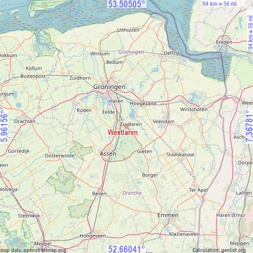
Westlaren GPS coordinates[2]
53° 5' 5.28" North, 6° 39' 52.884" East
| Map corner | latitude | longitude |
|---|---|---|
| Upper-left | 53.50505°, | 5.96156° |
| Center: | 53.0848°, | 6.66469° |
| Lower-right: | 52.66041°, | 7.36781° |
| Map W x H: | 93.9×93.9 km | = 58.3×58.3mi |
| max Lat: | 53.48025° ⇑11.6% North |
| Westlaren: | 53.0848° |
| min Lat: | ⇓88.4% South 50.76917° |
| min Long | Westlaren | max Long |
| 3.38611° | 6.66469° | 7.16528° |
| W 92.8%⇐ | ⇒7.2% E |
Elevation
Elevation of Westlaren is 8 m = 26 ft, and this is 7 m = 23 ft below average elevation for this country.
| Max E: |
203 m = 666 ft | 44.9% |
| Avg. | 15 m = 49 ft | |
| Westlaren | 8 m = 26 ft | |
Min E: |
-6 m = -20 ft | 55.1% |
See also: Netherlands elevation on elevation.city.
Geographical zone
Westlaren is located in North temperate zone (between Tropic of Cancer and the Arctic Circle). Distance of this North polar circle is 1498.7 km =931.2 mi to North.| Distance of | km | miles | from Westlaren |
|---|---|---|---|
| North Pole | 4104.6 | 2550.5 | to North |
| Arctic Circle | 1498.7 | 931.2 | to North |
| Tropic Cancer | 3296.6 | 2048.4 | to South |
| Equator | 5902.5 | 3667.6 | to South |


Nearby cities:
15 places around Westlaren: (largest is in red/bold)
• Annen
4.8 km =3 mi,  129°
129°
• Eelde
8.9 km =5.5 mi,  309°
309°
• Eext
8.8 km =5.5 mi,  147°
147°
• Glimmen
6.5 km =4 mi,  338°
338°
• Kiel-Windeweer
8.2 km =5.1 mi,  68°
68°
• Marsdijk
9.2 km =5.7 mi,  215°
215°
• Martenshoek
9.8 km =6.1 mi,  26°
26°
• Meerwijck
7.6 km =4.7 mi,  24°
24°
• Paterswolde
9.4 km =5.8 mi,  315°
315°
• Schipborg
1.2 km =0.7 mi,  159°
159°
• Tynaarlo
3.3 km =2.1 mi,  255°
255°
• Vries
5.9 km =3.7 mi, 258°
• Yde
5.9 km =3.7 mi, 305°
• Zeyen
9 km =5.6 mi,  242°
242°
• Zuidlaren
1.6 km =1 mi,  47°
47°
Sources, notices
• [Note1] Compared only with cities in Netherlands existing in our database
• [Src1] Map data: © OpenStreetMap contributors (CC-BY-SA)
• [Src2] Other city data from geonames.org with taken over terms of usage.
• [Src3] Geographical zone / Annual Mean Temperature by Robert A. Rohde @ Wikipedia
