Tynaarlo geodata
Tynaarlo (Drenthe) is a populated place; located in Netherlands in Europe/Amsterdam (GMT+2) time zone. With population of 1,530 people, there are 1115 cities with bigger population in this country. Compared to other cities in Netherlands, 88.1% of cities are located further ↓South; 91.7% of cities are located further ←West and 64.6% of cities have lower elevation than Tynaarlo. Note1


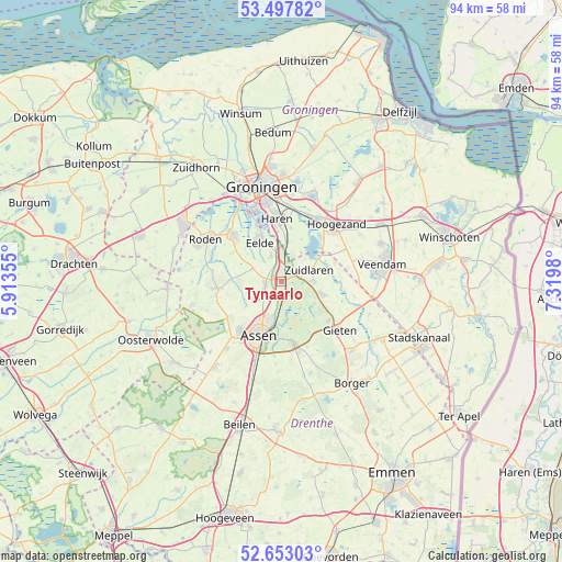
Tynaarlo GPS coordinates[2]
53° 4' 39" North, 6° 37' 0.012" East
| Map corner | latitude | longitude |
|---|---|---|
| Upper-left | 53.49782°, | 5.91355° |
| Center: | 53.0775°, | 6.61667° |
| Lower-right: | 52.65303°, | 7.3198° |
| Map W x H: | 93.9×93.9 km | = 58.3×58.3mi |
| max Lat: | 53.48025° ⇑11.9% North |
| Tynaarlo: | 53.0775° |
| min Lat: | ⇓88.1% South 50.76917° |
| min Long | Tynaarlo | max Long |
| 3.38611° | 6.61667° | 7.16528° |
| W 91.7%⇐ | ⇒8.3% E |
Elevation
Elevation of Tynaarlo is 12 m = 39 ft, and this is 3 m = 10 ft below average elevation for this country.
| Max E: |
203 m = 666 ft | 35.4% |
| Avg. | 15 m = 49 ft | |
| Tynaarlo | 12 m = 39 ft | |
Min E: |
-6 m = -20 ft | 64.6% |
See also: Netherlands elevation on elevation.city.
Geographical zone
Tynaarlo is located in North temperate zone (between Tropic of Cancer and the Arctic Circle). Distance of this North polar circle is 1499.5 km =931.7 mi to North.| Distance of | km | miles | from Tynaarlo |
|---|---|---|---|
| North Pole | 4105.4 | 2551 | to North |
| Arctic Circle | 1499.5 | 931.7 | to North |
| Tropic Cancer | 3295.7 | 2047.9 | to South |
| Equator | 5901.7 | 3667.1 | to South |


Nearby cities:
15 places around Tynaarlo: (largest is in red/bold)
• Annen
7.2 km =4.5 mi,  107°
107°
• Assen
9.7 km =6 mi,  201°
201°
• Eelde
7.4 km =4.6 mi,  330°
330°
• Eext
10.3 km =6.4 mi,  130°
130°
• Glimmen
6.9 km =4.3 mi,  6°
6°
• Marsdijk
7 km =4.3 mi, 197°
• Meerwijck
10 km =6.2 mi,  39°
39°
• Paterswolde
8.3 km =5.2 mi,  335°
335°
• Peelo
7.6 km =4.7 mi,  208°
208°
• Schipborg
3.6 km =2.2 mi,  94°
94°
• Vries
2.6 km =1.6 mi,  261°
261°
• Westlaren
3.3 km =2.1 mi,  75°
75°
• Yde
4.5 km =2.8 mi, 339°
• Zeyen
5.8 km =3.6 mi,  234°
234°
• Zuidlaren
4.7 km =2.9 mi,  66°
66°
Sources, notices
• [Note1] Compared only with cities in Netherlands existing in our database
• [Src1] Map data: © OpenStreetMap contributors (CC-BY-SA)
• [Src2] Other city data from geonames.org with taken over terms of usage.
• [Src3] Geographical zone / Annual Mean Temperature by Robert A. Rohde @ Wikipedia
